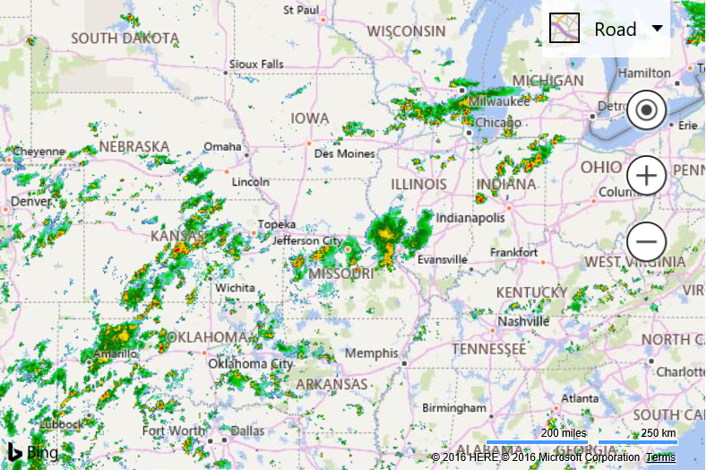
Animated Weather Radar Map
Note
Bing Maps Web Control SDK retirement
Bing Maps Web Control SDK is deprecated and will be retired. Free (Basic) account customers can continue to use Bing Maps Web Control SDK until June 30th, 2025. Enterprise account customers can continue to use Bing Maps Web Control SDK until June 30th, 2028. To avoid service disruptions, all implementations using Bing Maps Web Control SDK will need to be updated to use Azure Maps Web SDK by the retirement date that applies to your Bing Maps for Enterprise account type. For detailed migration guidance, see Migrate from Bing Maps Web Control SDK and Migrate Bing Maps Enterprise applications to Azure Maps with GitHub Copilot.
Azure Maps is Microsoft's next-generation maps and geospatial services for developers. Azure Maps has many of the same features as Bing Maps for Enterprise, and more. To get started with Azure Maps, create a free Azure subscription and an Azure Maps account. For more information about azure Maps, see Azure Maps Documentation. For migration guidance, see Bing Maps Migration Overview.
This example uses the AnimatedTileLayer to animate through an array of tile layers. For this example the weather radar tile service from the Iowa Environmental Mesonet of Iowa State University and animates it. This service provides radar images for the last 50 minutes over the USA broken up into 5 minute increments.
<!DOCTYPE html>
<html>
<head>
    <title></title>
    <meta charset="utf-8" />
	<script type='text/javascript'>
    var map, animatedLayer;

    //Weather tile url from Iowa Environmental Mesonet (IEM): https://mesonet.agron.iastate.edu/ogc/
    var urlTemplate = 'https://mesonet.agron.iastate.edu/cache/tile.py/1.0.0/nexrad-n0q-{timestamp}/{zoom}/{x}/{y}.png';

    //The time stamps values for the IEM service for the last 50 minutes broken up into 5 minute increments.
    var timestamps = ['900913-m50m', '900913-m45m', '900913-m40m', '900913-m35m', '900913-m30m', '900913-m25m', '900913-m20m', '900913-m15m', '900913-m10m', '900913-m05m', '900913'];

    function GetMap()
    {
        map = new Microsoft.Maps.Map('#myMap', {
            credentials: 'Your Bing Maps Key',
            center: new Microsoft.Maps.Location(39, -92),
            zoom: 5
        });

        var tileSources = [];

        //Create a tile source for each time stamp.
        for (var i = 0; i < timestamps.length; i++) {
            var tileSource = new Microsoft.Maps.TileSource({
                uriConstructor: urlTemplate.replace('{timestamp}', timestamps[i])
            });
            tileSources.push(tileSource);
        }

        //Create the animated tile layer and add it to the map.
        animatedLayer = new Microsoft.Maps.AnimatedTileLayer({
            mercator: tileSources,
            frameRate: 500
        });
        map.layers.insert(animatedLayer);
    }
    </script>
    <script type='text/javascript' src='http://www.bing.com/api/maps/mapcontrol?callback=GetMap' async defer></script>
</head>
<body>
    <div id="myMap" style="position:relative;width:600px;height:400px;"></div>
</body>
</html>
If you run this code you will briefly see a loading message on the map which is pre-loading the map tiles in the current map view for the animation. Once this message disappears the animation will begin and smoothly transition between each tile layer. If you pan or zoom the map the loading screen will appear again as new map tiles are preloaded for the new map view.
