MapScene.CreateFromLocationAndRadius Method
Definition
Important
Some information relates to prerelease product that may be substantially modified before it’s released. Microsoft makes no warranties, express or implied, with respect to the information provided here.
Overloads
| CreateFromLocationAndRadius(Geopoint, Double) |
Creates a scene to appear in a map based on a single geographic location and radius. |
| CreateFromLocationAndRadius(Geopoint, Double, Double, Double) |
Creates a scene to appear in a map based on a single geographic location, radius, heading, and pitch. |
CreateFromLocationAndRadius(Geopoint, Double)
Creates a scene to appear in a map based on a single geographic location and radius.
public:
 static MapScene ^ CreateFromLocationAndRadius(Geopoint ^ location, double radiusInMeters);
/// [Windows.Foundation.Metadata.Overload("CreateFromLocationAndRadius")]
static MapScene CreateFromLocationAndRadius(Geopoint const& location, double const& radiusInMeters);[Windows.Foundation.Metadata.Overload("CreateFromLocationAndRadius")]
public static MapScene CreateFromLocationAndRadius(Geopoint location, double radiusInMeters);function createFromLocationAndRadius(location, radiusInMeters)Public Shared Function CreateFromLocationAndRadius (location As Geopoint, radiusInMeters As Double) As MapSceneParameters
- location
- Geopoint
The center of the scene.
- radiusInMeters
-
Double
double
The radius around the center to appear in the scene, in meters.
Returns
Represents a view of a map in the MapControl.
- Attributes
Remarks
This constructor is equivalent to calling CreateFromLocationAndRadius(Geopoint, Double, Double, Double) with the following default parameter values: headingInDegrees = 0 (North) and pitchInDegrees = 0 (looking straight down). For more information, see the remarks section of the CreateFromLocationAndRadius(Geopoint, Double, Double, Double) method.
See also
Applies to
CreateFromLocationAndRadius(Geopoint, Double, Double, Double)
Creates a scene to appear in a map based on a single geographic location, radius, heading, and pitch.
public:
 static MapScene ^ CreateFromLocationAndRadius(Geopoint ^ location, double radiusInMeters, double headingInDegrees, double pitchInDegrees);
/// [Windows.Foundation.Metadata.Overload("CreateFromLocationAndRadiusWithHeadingAndPitch")]
static MapScene CreateFromLocationAndRadius(Geopoint const& location, double const& radiusInMeters, double const& headingInDegrees, double const& pitchInDegrees);[Windows.Foundation.Metadata.Overload("CreateFromLocationAndRadiusWithHeadingAndPitch")]
public static MapScene CreateFromLocationAndRadius(Geopoint location, double radiusInMeters, double headingInDegrees, double pitchInDegrees);function createFromLocationAndRadius(location, radiusInMeters, headingInDegrees, pitchInDegrees)Public Shared Function CreateFromLocationAndRadius (location As Geopoint, radiusInMeters As Double, headingInDegrees As Double, pitchInDegrees As Double) As MapSceneParameters
- location
- Geopoint
The center of the scene.
- radiusInMeters
-
Double
double
The radius around the center to appear in the scene, in meters.
- headingInDegrees
-
Double
double
The directional heading of the map's camera in degrees, where 0 or 360 = North, 90 = East, 180 = South, and 270 = West. The default headingInDegrees value is 0.
- pitchInDegrees
-
Double
double
The pitch of the map's camera in degrees, where 90 is looking out at the horizon (maximum) and 0 is looking straight down (minimum). The default pitchInDegrees value is 0.
Returns
Represents a view of a map in the MapControl.
- Attributes
Remarks
Tip
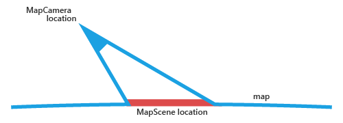
Use the CreateFromCamera method to create a scene by specifying the position of the map's camera. The location specified in this method by the location parameter is the location that will appear in the scene, it's not the location of the map's camera.
The following image demonstrates the location of the scene relative to the map's camera. The location specified in this method by the location parameter corresponds to the MapScene location.
 The valid range of pitch differs between 2D, 3D, and Streetside map views. When switching from 3D to 2D for example, values that are acceptable in the current view may be out of range in the next view. If that’s the case, the current pitch value will be truncated to the nearest acceptable value in the next view.
When leaving a Streetside view, the map returns to the previous view settings. The Streetside pitch is not maintained outside of the Streetside experience.
The maximum and minimum values of pitch/tilt depend on the type of map view: 2D, 3D, or Streetside.
| Property | 2D range | 3D range | Streetside range |
|---|---|---|---|
| pitch/tilt | 0-75 | 0-90 | 0-180 |
Heading values greater than 360 degrees are normalized to their equivalent 0-360 degree value.