建立自訂外掛程式以使用您偏好的地理空間資料提供者
本文提供相關資訊,讓您了解 Universal Resource Scheduling 中的兩個地理空間動作、如何為這兩個地理空間動作建立自訂外掛程式,並提供範例自訂外掛程式中有關使用 Google Maps API 處理地理空間資料的的範例。
地理空間動作的輸入和輸出參數
撰寫自訂外掛程式時,必須考慮地理空間動作的輸入和輸出參數,這樣您才知道要傳入什麼資料,以及外掛程式程式碼中預期的輸出資料。
有兩種方式可以檢視這兩個地理空間動作的輸入和輸出參數:
- Web API 動作參照內容:檢視關於 Universal Resource Scheduling 中地理空間動作的參考資訊。
Microsoft.Dynamics.CRM.msdyn_RetrieveDistanceMatrix
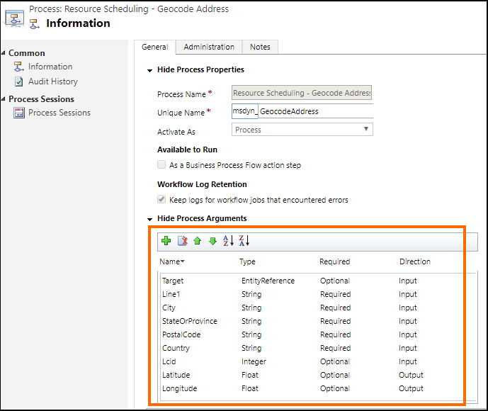
- 動作定義:如需有關輸入/輸出參數的詳細資訊 (包括關於參數是必要還是選用的資訊),您可以檢視 Dynamics 365 中的動作定義。
Note
本文章/表格中提到的 Web API 類型和作業可在您的環境中使用,而且您可以使用環境或 Postman 的服務文件來探索這些類型和作業。 其他資訊:Web API 服務文件和將 Postman 與 Microsoft Dataverse Web API 搭配使用。
若要檢視動作定義,請選取設定>程序。 接下來,搜尋動作名稱:資源排程 - 地理編碼地址或資源排程 - 擷取距離矩陣,然後選取方格中的動作以顯示其定義。 例如,以下是資源排程 - 地理編碼地址 (msdyn_GeocodeAddress) 動作的定義,其中醒目提示的區域會提供關於輸入和輸出參數的資訊。
撰寫自訂外掛程式
角色是實作 IPlugin 介面的自訂類別。 如需有關建立外掛程式的詳細資訊,請參閱外掛程式開發
自訂外掛程式範例是提供給您作參考,示範如何使用 Google Maps API (而不使用預設的 Bing 地圖服務 API) 提供現場作業所需的地理空間資料。 其他資訊:範例:要使用 Google Maps API 做為地理空間資料提供者的自訂外掛程式。
每個範例外掛程式中的下列程式碼會使用 Google API 提供的資料:
msdyn_GeocodeAddress.cs 外掛程式檔案中的 ExecuteGeocodeAddress 方法
public void ExecuteGeocodeAddress(IPluginExecutionContext pluginExecutionContext, IOrganizationService organizationService, ITracingService tracingService)
{
    //Contains 5 fields (string) for individual parts of an address
    ParameterCollection InputParameters = pluginExecutionContext.InputParameters;
    // Contains 2 fields (double) for resultant geolocation
    ParameterCollection OutputParameters = pluginExecutionContext.OutputParameters;
    //Contains 1 field (int) for status of previous and this plugin
    ParameterCollection SharedVariables = pluginExecutionContext.SharedVariables;

    tracingService.Trace("ExecuteGeocodeAddress started. InputParameters = {0}, OutputParameters = {1}", InputParameters.Count().ToString(), OutputParameters.Count().ToString());


    try
    {
        // If a plugin earlier in the pipeline has already geocoded successfully, quit
        if ((double)OutputParameters[LatitudeKey] != 0d || (double)OutputParameters[LongitudeKey] != 0d) return;

        // Get user Lcid if request did not include it
        int Lcid = (int)InputParameters[LcidKey];
        string _address = string.Empty;
        if (Lcid == 0)
        {
            var userSettingsQuery = new QueryExpression("usersettings");
            userSettingsQuery.ColumnSet.AddColumns("uilanguageid", "systemuserid");
            userSettingsQuery.Criteria.AddCondition("systemuserid", ConditionOperator.Equal, pluginExecutionContext.InitiatingUserId);
            var userSettings = organizationService.RetrieveMultiple(userSettingsQuery);
            if (userSettings.Entities.Count > 0)
                Lcid = (int)userSettings.Entities[0]["uilanguageid"];
        }

        // Arrange the address components in a single comma-separated string, according to LCID
        _address = GisUtility.FormatInternationalAddress(Lcid,
            (string)InputParameters[Address1Key],
            (string)InputParameters[PostalCodeKey],
            (string)InputParameters[CityKey],
            (string)InputParameters[StateKey],
            (string)InputParameters[CountryKey]);

        // Make Geocoding call to Google API
        WebClient client = new WebClient();
        var url = $"https://{GoogleConstants.GoogleApiServer}{GoogleConstants.GoogleGeocodePath}/json?address={_address}&key={GoogleConstants.GoogleApiKey}";
        tracingService.Trace($"Calling {url}\n");
        string response = client.DownloadString(url);   // Post ...

        tracingService.Trace("Parsing response ...\n");
        DataContractJsonSerializer jsonSerializer = new DataContractJsonSerializer(typeof(GeocodeResponse));    // Deserialize response json
        object objResponse = jsonSerializer.ReadObject(new MemoryStream(Encoding.UTF8.GetBytes(response)));     // Get response as an object
        GeocodeResponse geocodeResponse = objResponse as GeocodeResponse;       // Unbox into our data contracted class for response

        tracingService.Trace("Response Status = " + geocodeResponse.Status + "\n");
        if (geocodeResponse.Status != "OK")
            throw new ApplicationException($"Server {GoogleConstants.GoogleApiServer} application error (Status {geocodeResponse.Status}).");

        tracingService.Trace("Checking geocodeResponse.Result...\n");
        if (geocodeResponse.Results != null)
        {
            if (geocodeResponse.Results.Count() == 1)
            {
                tracingService.Trace("Checking geocodeResponse.Result.Geometry.Location...\n");
                if (geocodeResponse.Results.First()?.Geometry?.Location != null)
                {
                    tracingService.Trace("Setting Latitude, Longitude in OutputParameters...\n");

                    // update output parameters
                    OutputParameters[LatitudeKey] = geocodeResponse.Results.First().Geometry.Location.Lat;
                    OutputParameters[LongitudeKey] = geocodeResponse.Results.First().Geometry.Location.Lng;

                }
                else throw new ApplicationException($"Server {GoogleConstants.GoogleApiServer} application error (missing Results[0].Geometry.Location)");
            }
            else throw new ApplicationException($"Server {GoogleConstants.GoogleApiServer} application error (more than 1 result returned)");
        }
        else throw new ApplicationException($"Server {GoogleConstants.GoogleApiServer} application error (missing Results)");
    }
    catch (Exception ex)
    {
        // Signal to subsequent plugins in this message pipeline that geocoding failed here.
        OutputParameters[LatitudeKey] = 0d;
        OutputParameters[LongitudeKey] = 0d;

        //TODO: You may need to decide which caught exceptions will rethrow and which ones will simply signal geocoding did not complete.
        throw new InvalidPluginExecutionException(string.Format("Geocoding failed at {0} with exception -- {1}: {2}"
            , GoogleConstants.GoogleApiServer, ex.GetType().ToString(), ex.Message), ex);
    }

}
msdyn_RetrieveDistanceMatrix.cs 外掛程式檔案中的 ExecuteDistanceMatrix 方法
public void ExecuteDistanceMatrix(IPluginExecutionContext pluginExecutionContext, IOrganizationService organizationService, ITracingService tracingService)
{
    //Contains 2 fields (EntityCollection) for sources and targets
    ParameterCollection InputParameters = pluginExecutionContext.InputParameters;
    // Contains 1 field (EntityCollection) for results
    ParameterCollection OutputParameters = pluginExecutionContext.OutputParameters;
    //Contains 1 field (int) for status of previous and this plugin
    ParameterCollection SharedVariables = pluginExecutionContext.SharedVariables;

    tracingService.Trace("ExecuteDistanceMatrix started.  InputParameters = {0},OutputParameters = {1}", InputParameters.Count().ToString(), OutputParameters.Count().ToString());

    try
    {
        // If a plugin earlier in the pipeline has already retrieved a distance matrix successfully, quit
        if (OutputParameters[MatrixKey] != null)
            if (((EntityCollection)OutputParameters[MatrixKey]).Entities != null)
                if (((EntityCollection)OutputParameters[MatrixKey]).Entities.Count > 0) return;

        // Make Distance Matrix call to Google API
        WebClient client = new WebClient();
        var url = String.Format($"https://{GoogleConstants.GoogleApiServer}{GoogleConstants.GoogleDistanceMatrixPath}/json"
            + "?units=imperial"
            + $"&origins={string.Join("|", ((EntityCollection)InputParameters[SourcesKey]).Entities.Select(e => e.GetAttributeValue<double?>("latitude") + "," + e.GetAttributeValue<double?>("longitude")))}"
            + $"&destinations={string.Join("|", ((EntityCollection)InputParameters[TargetsKey]).Entities.Select(e => e.GetAttributeValue<double?>("latitude") + "," + e.GetAttributeValue<double?>("longitude")))}"
            + $"&key={GoogleConstants.GoogleApiKey}");
        tracingService.Trace($"Calling {url}\n");
        string response = client.DownloadString(url);   // Post ...

        tracingService.Trace("Parsing response ...\n");
        DataContractJsonSerializer jsonSerializer = new DataContractJsonSerializer(typeof(DistanceMatrixResponse));    // Deserialize response json
        object objResponse = jsonSerializer.ReadObject(new MemoryStream(Encoding.UTF8.GetBytes(response)));     // Get response as an object
        DistanceMatrixResponse distancematrixResponse = objResponse as DistanceMatrixResponse;       // Unbox as our data contracted class for response

        tracingService.Trace("Response Status = " + distancematrixResponse.Status + "\n");
        if (distancematrixResponse.Status != "OK")
            throw new ApplicationException($"Server {GoogleConstants.GoogleApiServer} application error (Status={distancematrixResponse.Status}). {distancematrixResponse.ErrorMessage}");

        tracingService.Trace("Checking distancematrixResponse.Results...\n");
        if (distancematrixResponse.Rows != null)
        {
            tracingService.Trace("Parsing distancematrixResponse.Results.Elements...\n");

            // build and update output parameter
            var result = new EntityCollection();
            result.Entities.AddRange(distancematrixResponse.Rows.Select(r => ToEntity(r.Columns.Select(c => ToEntity(c.Status, c.Duration, c.Distance)).ToArray())));
            OutputParameters[MatrixKey] = result;

        }
        else throw new ApplicationException($"Server {GoogleConstants.GoogleApiServer} application error (missing Rows)");
    }
    catch (Exception ex)
    {
        // Signal to subsequent plugins in this message pipeline that retrieval of distance matrix failed here.
        OutputParameters[MatrixKey] = null;

        //TODO: You may need to decide which caught exceptions will rethrow and which ones will simply signal geocoding did not complete.
        throw new InvalidPluginExecutionException(string.Format("Geocoding failed at {0} with exception -- {1}: {2}"
            , GoogleConstants.GoogleApiServer, ex.GetType().ToString(), ex.Message), ex);
    }

    // For debugging purposes, throw an exception to see the details of the parameters
    CreateExceptionWithDetails("Debugging...", InputParameters, OutputParameters, SharedVariables);
}
撰寫自訂外掛程式的程式碼之後,建置專案以產生外掛程式組件 (.dll),用來註冊 Universal Resource Scheduling 地理空間動作上的外掛程式。