Google Hype: Google Maps
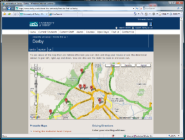
I've been asked to do Vista & Office event at Derby University in February and I went on to the University website to find out the location of their campus. Now back in the day, Google were innovative with with their Map service and the University have used it to create an interactive map showing where the different campuses are in Derby.
When I'm figuring out where I'm travelling to I don't use Google Maps - not because I'm a Microsoftie but because Live.com maps is a better, more useful mapping service. I'll tell you why.
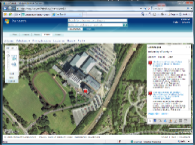
On Live.com Maps, I can find the campus location and then I can view an overhead aerial photograph of the area and find the building. But wait, I can do that with Google Maps right? Yes you can. What you can't then do is switch to "Bird's Eye View" which gives me a fantastic isometric view of the area - check out the screenshot! I find this really useful to familiarise myself with the area before driving - the basic overhead shot is good but this is better for my sense of direction and to recognise landmarks.
I can even choose a compass direction from which to view the isometric shot from so I can checkout different angles around a particular building - in my example I can see all four sides of the University of Derby's main campus - I can even see the flags that they feature in the image on their website.

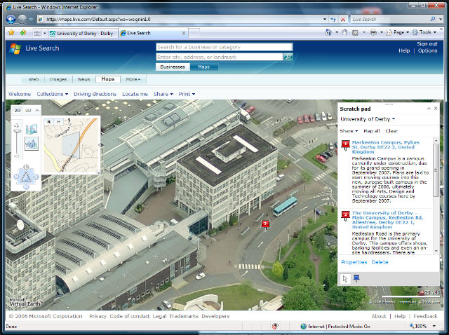
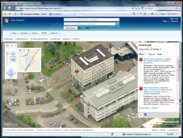
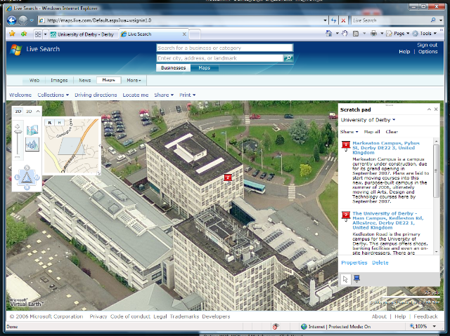
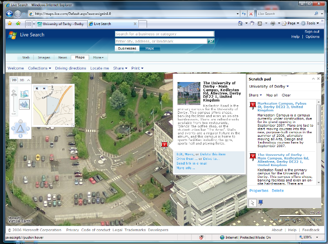
I've also created a public collection of three of the Campus buildings (you can check it out here). In this collection I've also added a bit of blurb about each location, a link to the relevant campus page on the University's website and a link to an image on their website! Now when I hover over the pushpin, I get a little panel show up which gives me the blurb, the link and a nice picture of the location. On the main campus image I can even see the flags that I mentioned earlier on Bird's eye view!
I've also made this map searchable so that Live.com searches can pick it up using tags!
I thought I also better mention the Virtual Earth plugin for IE that you allows you to view a 3D model of the area right in your browser... admitidely they haven't got the 3D models mapped for Derby, but it's only a matter of time!!! :-)
Mike P in my team has got some interesting posts on how you can get the VE and Live.com Maps technology on your website as well as integrating Live.com search on your website like The Times online and The Register have done:
Virtual Earth Technology: SDK Release use for your website today!
Want some help adding Live Search to your websites - great msdn article!
Challenge to Derby Uni
My challenge to Derby University is to take my collection and finish it by adding all the other campuses to it and getting it online on their website in time for me arriving on the 21st of February. Otherwise, I'm not going to be able to find out where I'm going and I'll probably be late for the event!!!
So why the title of this post? Google are doing cool things with technology but Microsoft are doing very cool stuff as well. The maps thing is an example of technology that doesn't get the press and attention it deserves.
Comments
Anonymous
January 01, 2003
Just a quick sign posting to James Senior's blog on mapping and the differing technologies from GoogleAnonymous
January 01, 2003
I wrote recently about the Google Hype particularly on mapping technology and Mike has continued theAnonymous
January 01, 2003
Tony, Virtual Wifi? Not even sure what that is mate! Can you point me to a good resource? JamesAnonymous
January 01, 2003
Then stick it in a device that i can take in my car and you have one compelling product! Is anyone from TomTom listening? :-)Anonymous
January 01, 2003
That's the beauty of it! It's the ulimate hardware/software mashup... I'll look into LCD's :-)Anonymous
January 01, 2003
Hey Tim the texture skins are the hardest thing to do, which is why Google only have grey boxes at the moment. The community thing is cool with google earth but there is also value in having it in browser. Also, you can get Virtual Earth in Outlook so when you are planning your meetings you can check out the location in 3D :-) @Tony When are you bringing the product out? :)Anonymous
January 24, 2007
Just think how cool Live Maps is going to be when the "Street Level" images are completed! (^_^) http://preview.local.live.com/Anonymous
January 24, 2007
James, mini-itx car pc with xpe with usb gps puck and live maps and a very little code and BOOM tomtom doesn't look so good. Add vwifi and things get real screwey as to what can be done...Anonymous
January 24, 2007
hey dude, there is also this c9 video about their 3d technology. apart from the fact that you can fly around using an xbox controller and they sell ad-space in the world of 3d: the totally cool thing is their method of 3d buildings. msft aquired some company a couple of years ago which flies planes around the cities and uses some clever software to render the 3d buildings and you get proper textured overlays. this may not still be the case but on google earth you just see big grey boxes which have to be drawn manually using their sketch up product. on the flip side; google earth has the community thing with keyhole and that adds massive value. I would like to see msft host their 3d stuff in a rich/native stand-alone app.Anonymous
January 25, 2007
flippin if I could find some better/cheaper lcd's with touch I'd be more inclined to publish the whole enchilada. What I'm doing is just pasting serveral different technologies together nothing special except the vwifi stuff, think free onstar!Anonymous
January 25, 2007
I haven't yet played with vista yet but will be dl'ing (via ms) asap. My question is did they do anything with vwifi in vista?