Using the Google Maps API in your application
Using the Maps application is great, but sometimes you want to include maps directly in your application. In addition to the built-in maps application, Google also offers a native mapping API for Android. The Maps API is suitable for cases where you want to maintain more control over the mapping experience. Things that are possible with the Maps API include:
- Programmatically changing the viewpoint of the map.
- Adding and customizing markers.
- Annotating a map with overlays.
Unlike the now-deprecated Google Maps Android API v1, Google Maps Android API v2 is part of Google Play Services. A Xamarin.Android app must meet some mandatory prerequisites before it is possible to use the Google Maps Android API.
Google Maps API prerequisites
Several steps need to be taken before you can use the Maps API, including:
- Obtain a Maps API key
- Install the Google Play Services SDK
- Install the Xamarin.GooglePlayServices.Maps package from NuGet
- Specify the required permissions
- Optionally, Create an emulator with the Google APIs
Obtain a Google Maps API Key
The first step is to get a Google Maps API key (note that you cannot reuse an API key from the legacy Google Maps v1 API). For information about how to obtain and use the API key with Xamarin.Android, see Obtaining A Google Maps API Key.
Install the Google Play Services SDK
Google Play Services is a technology from Google that allows Android applications to take advantage of various Google features such as Google+, In-App Billing, and Maps. These features are accessible on Android devices as background services, which are contained in the Google Play Services APK.
Android applications interact with Google Play Services through the Google Play Services client library. This library contains the interfaces and classes for the individual services such as Maps. The following diagram shows the relationship between an Android application and Google Play Services:
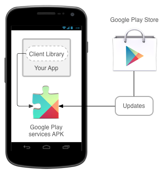
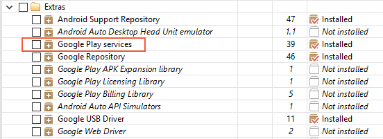
The Android Maps API is provided as a part of Google Play Services. Before a Xamarin.Android application can use the Maps API, the Google Play Services SDK must be installed using the Android SDK Manager. The following screenshot shows where in the Android SDK Manager the Google Play services client can be found:
Note
The Google Play services APK is a licensed product that may not be present on all devices. If it is not installed, then Google Maps will not work on the device.
Install the Xamarin.GooglePlayServices.Maps package from NuGet
The Xamarin.GooglePlayServices.Maps package contains the Xamarin.Android bindings for the Google Play Services Maps API. To add the Google Play Services Map package, right-click the References folder of your project in the Solution Explorer and click Manage NuGet Packages...:
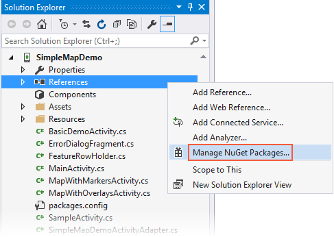
This opens the NuGet Package Manager. Click Browse and enter Xamarin Google Play Services Maps in the search field. Select Xamarin.GooglePlayServices.Maps and click Install. (If this package had been installed previously, click Update.):
Notice that the following dependency packages are also installed:
- Xamarin.GooglePlayServices.Base
- Xamarin.GooglePlayServices.Basement
- Xamarin.GooglePlayServices.Tasks
Specify the required permissions
Apps must identify the hardware and permission requirements in order to use the Google Maps API. Some permissions are automatically granted by the Google Play Services SDK, and it is not necessary for a developer to explicitly add them to AndroidManfest.XML:
Access to the Network State – The Maps API must be able to check if it can download the map tiles.
Internet Access – Internet access is necessary to download the map tiles and communicate with the Google Play Servers for API access.
The following permissions and features must be specified in the AndroidManifest.XML for the Google Maps Android API:
OpenGL ES v2 – The application must declare the requirement for OpenGL ES v2.
Google Maps API Key – The API key is used to confirm that the application is registered and authorized to use Google Play Services. See Obtaining a Google Maps API Key for details about this key.
Request the legacy Apache HTTP client – Apps that target Android 9.0 (API level 28) or above must specify that the legacy Apache HTTP client is an optional library to use.
Access to the Google Web-based Services – The application needs permissions to access Google's web services that back the Android Maps API.
Permissions for Google Play Services Notifications – The application must be granted permission to receive remote notifications from Google Play Services.
Access to Location Providers – These are optional permissions. They will allow the
GoogleMapclass to display the location of the device on the map.
In addition, Android 9 has removed the Apache HTTP client library from the bootclasspath, and so it isn't available to applications that target API 28 or higher. The following line must be added to the application node of your AndroidManifest.xml file to continue using the Apache HTTP client in applications that target API 28 or higher:
<application ...>
   ...
   <uses-library android:name="org.apache.http.legacy" android:required="false" />
</application>
Note
Very old versions of the Google Play SDK required an app to request the WRITE_EXTERNAL_STORAGE permission. This requirement is no longer necessary with the recent Xamarin bindings for Google Play Services.
The following snippet is an example of the settings that must be added to AndroidManifest.XML:
<?xml version="1.0" encoding="utf-8"?>
<manifest xmlns:android="http://schemas.android.com/apk/res/android" android:versionName="4.5" package="com.xamarin.docs.android.mapsandlocationdemo2" android:versionCode="6">
    <uses-sdk android:minSdkVersion="23" android:targetSdkVersion="28" />

    <!-- Google Maps for Android v2 requires OpenGL ES v2 -->
    <uses-feature android:glEsVersion="0x00020000" android:required="true" />

    <!-- Necessary for apps that target Android 9.0 or higher -->
    <uses-library android:name="org.apache.http.legacy" android:required="false" />

    <!-- Permission to receive remote notifications from Google Play Services -->
    <!-- Notice here that we have the package name of our application as a prefix on the permissions. -->
    <uses-permission android:name="<PACKAGE NAME>.permission.MAPS_RECEIVE" />
    <permission android:name="<PACKAGE NAME>.permission.MAPS_RECEIVE" android:protectionLevel="signature" />

    <!-- These are optional, but recommended. They will allow Maps to use the My Location provider. -->
    <uses-permission android:name="android.permission.ACCESS_COARSE_LOCATION" />
    <uses-permission android:name="android.permission.ACCESS_FINE_LOCATION" />

    <application android:label="@string/app_name">
        <!-- Put your Google Maps V2 API Key here. -->
        <meta-data android:name="com.google.android.maps.v2.API_KEY" android:value="YOUR_API_KEY" />
        <meta-data android:name="com.google.android.gms.version" android:value="@integer/google_play_services_version" />
        <!-- Necessary for apps that target Android 9.0 or higher -->
        <uses-library android:name="org.apache.http.legacy" android:required="false" />
    </application>
</manifest>
In addition to requesting the permissions AndroidManifest.XML, an app must also perform runtime permission checks for the ACCESS_COARSE_LOCATION and the ACCESS_FINE_LOCATION permissions. See the Xamarin.Android Permissions guide for more information about performing run-time permission checks.
Create an Emulator with Google APIs
In the event that a physical Android device with Google Play services is not installed, it is possible to create an emulator image for development. For more information see the Device Manager.
The GoogleMap Class
Once the prerequisites are satisfied, it is time to start developing the application and use the Android Maps API. The GoogleMap class is the main API that a Xamarin.Android application will use to display and interact with a Google Maps for Android. This class has the following responsibilities:
Interacting with Google Play services to authorize the application with the Google web service.
Downloading, caching, and displaying the map tiles.
Displaying UI controls such as pan and zoom to the user.
Drawing markers and geometric shapes on maps.
The GoogleMap is added to an Activity in one of two ways:
MapFragment - The MapFragment is a specialized Fragment that acts as host for the
GoogleMapobject. TheMapFragmentrequires Android API level 12 or higher. Older versions of Android can use the SupportMapFragment. This guide will focus on using theMapFragmentclass.MapView - The MapView is a specialized View subclass, which can act as a host for a
GoogleMapobject. Users of this class must forward all of the Activity lifecycle methods to theMapViewclass.
Each of these containers exposes a Map property that returns an
instance of GoogleMap. Preference should be given to the
MapFragment
class as it is a simpler API that reduces the amount boilerplate code
that a developer must manually implement.
Adding a MapFragment to an Activity
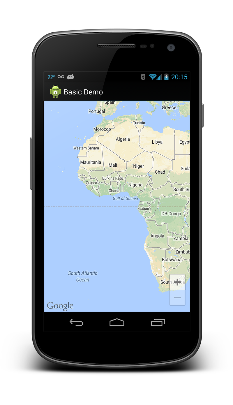
The following screenshot is an example of a simple MapFragment:
Similar to other Fragment classes, there are two ways to add a
MapFragment to an Activity:
Declaratively - The
MapFragmentcan be added via the XML layout file for the Activity. The following XML snippet shows an example of how to use thefragmentelement:<?xml version="1.0" encoding="utf-8"?> <fragment xmlns:android="http://schemas.android.com/apk/res/android" android:id="@+id/map" android:layout_width="match_parent" android:layout_height="match_parent" class="com.google.android.gms.maps.MapFragment" />Programmatically - The
MapFragmentcan be programmatically instantiated using theMapFragment.NewInstancemethod and then added to an Activity. This snippet shows the simplest way to instantiate aMapFragmentobject and add to an Activity:var mapFrag = MapFragment.NewInstance(); activity.FragmentManager.BeginTransaction() .Add(Resource.Id.map_container, mapFrag, "map_fragment") .Commit();It is possible to configure the
MapFragmentobject by passing aGoogleMapOptionsobject toNewInstance. This is discussed in the section GoogleMap properties that appears later on in this guide.
The MapFragment.GetMapAsync method is used to initialize the GoogleMap that is hosted by the fragment and obtain a reference to the map object that is hosted by the MapFragment. This method takes an object that implements the IOnMapReadyCallback interface.
This interface has a single method, IMapReadyCallback.OnMapReady(MapFragment map) that will be invoked when it is possible for the app to interact with the GoogleMap object. The following code snippet shows how an Android Activity can initialize a MapFragment and implement the IOnMapReadyCallback interface:
public class MapWithMarkersActivity : AppCompatActivity, IOnMapReadyCallback
{
    protected override void OnCreate(Bundle bundle)
    {
        base.OnCreate(bundle);
        SetContentView(Resource.Layout.MapLayout);

        var mapFragment = (MapFragment) FragmentManager.FindFragmentById(Resource.Id.map);
        mapFragment.GetMapAsync(this);

        // remainder of code omitted
    }

    public void OnMapReady(GoogleMap map)
    {
        // Do something with the map, i.e. add markers, move to a specific location, etc.
    }
}
Map types
There are five different types of maps available from the Google Maps API:
Normal - This is the default map type. It shows roads and important natural features along with some artificial points of interest (such as buildings and bridges).
Satellite - This map shows satellite photography.
Hybrid - This map shows satellite photography and road maps.
Terrain - This primarily shows topographical features with some roads.
None - This map does not load any tiles, it is rendered as an empty grid.
The image below shows three of the different types of maps, from left-to-right (normal, hybrid, terrain):
The GoogleMap.MapType property is used to set or change which type of
map is displayed. The following code snippet shows how to display a
satellite map.
public void OnMapReady(GoogleMap map)
{
    map.MapType = GoogleMap.MapTypeHybrid;
}
GoogleMap properties
GoogleMap defines several properties that can control the functionality
and the appearance of the map. One way to configure the initial state
of a GoogleMap is to pass a
GoogleMapOptions
object when creating a MapFragment. The following code snippet is one
example of using a GoogleMapOptions object when creating a MapFragment:
GoogleMapOptions mapOptions = new GoogleMapOptions()
    .InvokeMapType(GoogleMap.MapTypeSatellite)
    .InvokeZoomControlsEnabled(false)
    .InvokeCompassEnabled(true);

FragmentTransaction fragTx = FragmentManager.BeginTransaction();
mapFragment = MapFragment.NewInstance(mapOptions);
fragTx.Add(Resource.Id.map, mapFragment, "map");
fragTx.Commit();
The other way to configure a GoogleMap is by manipulating properties on the
UiSettings
of the map object. The next code sample shows how to configure a
GoogleMap to display the zoom controls and a compass:
public void OnMapReady(GoogleMap map)
{
    map.UiSettings.ZoomControlsEnabled = true;
    map.UiSettings.CompassEnabled = true;
}
Interacting with the GoogleMap
The Android Maps API provides APIs that allow an Activity to change the viewpoint, add markers, place custom overlays, or draw geometric shapes. This section will discuss how to accomplish some of these tasks in Xamarin.Android.
Changing the Viewpoint
Maps are modelled as a flat plane on the screen, based on the Mercator
projection. The map view is that of a camera looking straight down on
this plane. The position of the camera can be controlled by changing
the location, zoom, tilt, and bearing. The
CameraUpdate
class is used to move the camera location. CameraUpdate objects are not
directly instantiated, instead the Maps API provides the
CameraUpdateFactory
class.
Once a CameraUpdate object has been created, it is passed as a
parameter to either the
GoogleMap.MoveCamera
or
GoogleMap.AnimateCamera
methods. The MoveCamera method updates the map instantly while the
AnimateCamera method provides a smooth, animated transition.
This code snippet is a simple example of how to use the
CameraUpdateFactory to create a CameraUpdate that will increment
the zoom level of the map by one zoom level:
MapFragment mapFrag = (MapFragment) FragmentManager.FindFragmentById(Resource.Id.my_mapfragment_container);
mapFrag.GetMapAsync(this);
...

public void OnMapReady(GoogleMap map)
{
    map.MoveCamera(CameraUpdateFactory.ZoomIn());
}
The Maps API provides a
CameraPosition
which will aggregate all of the possible values for the camera
position. An instance of this class can be provided to the
CameraUpdateFactory.NewCameraPosition
method which will return a CameraUpdate object. The Maps API also
includes the
CameraPosition.Builder
class that provides a fluent API for creating CameraPosition objects.
The following code snippet shows an example of creating a CameraUpdate
from a CameraPosition and using that to change the camera position on a
GoogleMap:
public void OnMapReady(GoogleMap map)
{
    LatLng location = new LatLng(50.897778, 3.013333);

    CameraPosition.Builder builder = CameraPosition.InvokeBuilder();
    builder.Target(location);
    builder.Zoom(18);
    builder.Bearing(155);
    builder.Tilt(65);

    CameraPosition cameraPosition = builder.Build();

    CameraUpdate cameraUpdate = CameraUpdateFactory.NewCameraPosition(cameraPosition);

    map.MoveCamera(cameraUpdate);
}
In the previous code snippet, a specific location on the map is
represented by the
LatLng
class. The zoom level is set to 18, which is an arbitrary measure of zoom used by Google Maps. The bearing is the compass
measurement clockwise from North. The Tilt property controls the
viewing angle and specifies an angle of 25 degrees from the
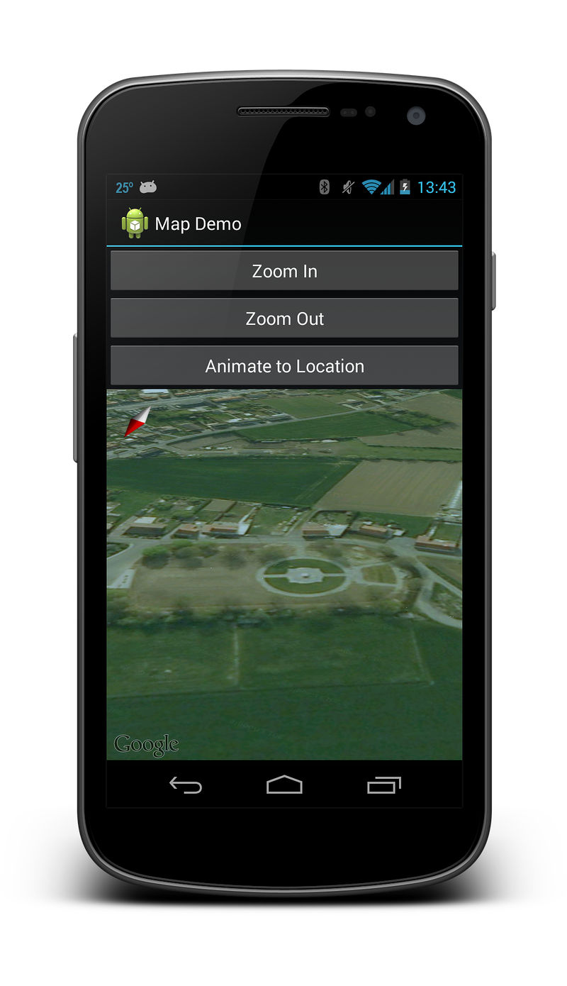
vertical. The following screenshot shows the GoogleMap after executing
the preceding code:
Drawing on the Map
The Android Maps API provides API's for drawing the following items on a map:
Markers - These are special icons that are used to identify a single location on a map.
Overlays - This is an image that can be used to identify a collection of locations or area on the map.
Lines, Polygons, and Circles - These are APIs that allow Activities to add shapes to a map.
Markers
The Maps API provides a Marker class which encapsulates all of the data about a single location on a map. By default the Marker class uses a standard icon provided by Google Maps. It is possible to customize the appearance of a marker and to respond to user clicks.
Adding a Marker
To add a marker to a map, it is necessary create a new
MarkerOptions object and then call the
AddMarker
method on a GoogleMap instance. This method will return a
Marker
object.
public void OnMapReady(GoogleMap map)
{
    MarkerOptions markerOpt1 = new MarkerOptions();
    markerOpt1.SetPosition(new LatLng(50.379444, 2.773611));
    markerOpt1.SetTitle("Vimy Ridge");

    map.AddMarker(markerOpt1);
}
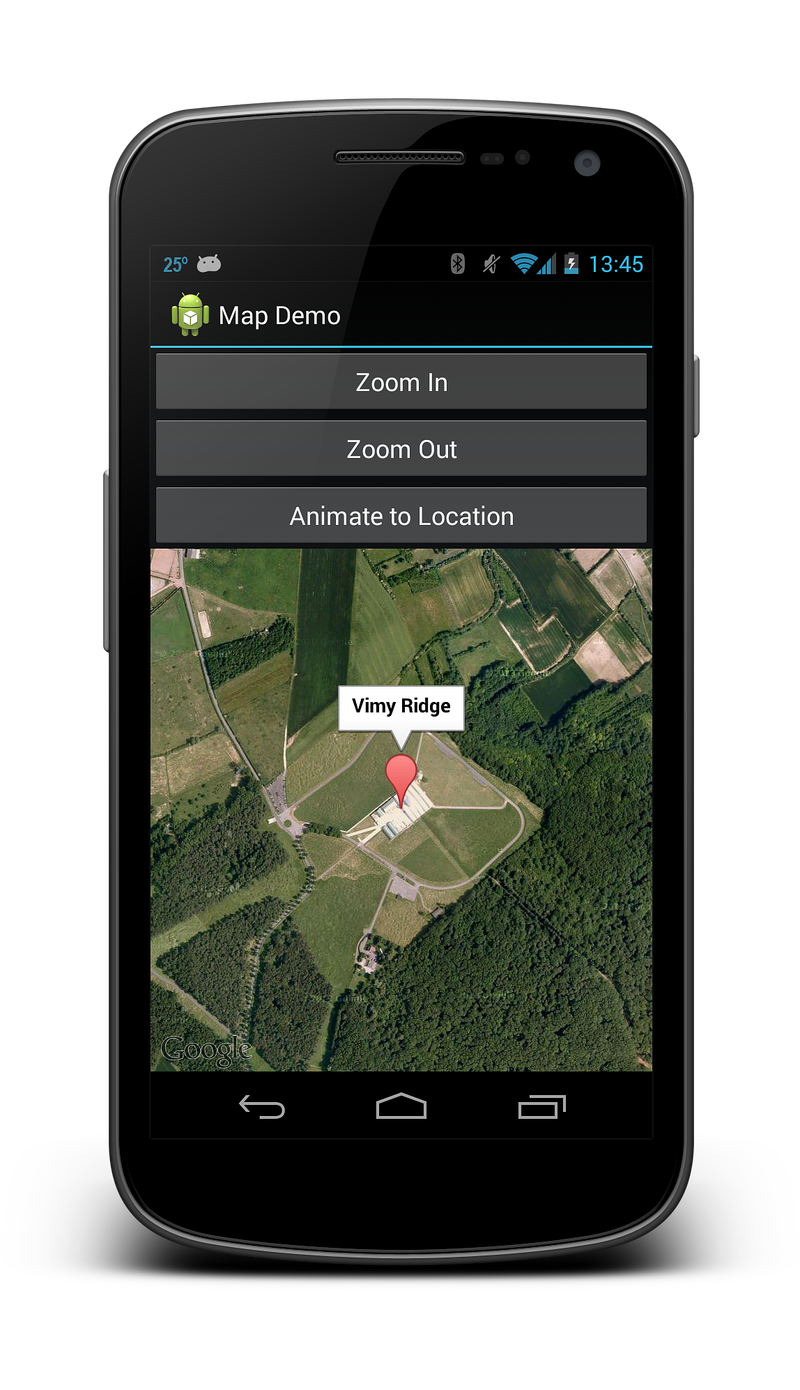
The title of the marker will be displayed in an info window when the user taps on the marker. The following screenshot shows what this marker looks like:
Customizing A Marker
It is possible to customize the icon used by the marker by calling the
MarkerOptions.InvokeIcon method when adding the marker to the map.
This method takes a
BitmapDescriptor
object containing the data necessary to render the icon. The
BitmapDescriptorFactory
class provides some helper methods to simplify the creation of a
BitmapDescriptor. The following list introduces some of these methods:
DefaultMarker(float colour)– Use the default Google Maps marker, but change the colour.FromAsset(string assetName)– Use a custom icon from the specified file in the Assets folder.FromBitmap(Bitmap image)– Use the specified bitmap as the icon.FromFile(string fileName)– Create the custom icon from the file at the specified path.FromResource(int resourceId)– Create a custom icon from the specified resource.
The following code snippet shows an example of creating a cyan coloured default marker:
public void OnMapReady(GoogleMap map)
{
    MarkerOptions markerOpt1 = new MarkerOptions();
    markerOpt1.SetPosition(new LatLng(50.379444, 2.773611));
    markerOpt1.SetTitle("Vimy Ridge");

    var bmDescriptor = BitmapDescriptorFactory.DefaultMarker (BitmapDescriptorFactory.HueCyan);
    markerOpt1.InvokeIcon(bmDescriptor);

    map.AddMarker(markerOpt1);
}
Info windows
Info windows are special windows that popup to display information to the user when they tap a specific marker. By default the info window will display the contents of the marker's title. If the title has not been assigned, then no info window will appear. Only one info window may be shown at a time.
It is possible to customize the info window by implementing the GoogleMap.IInfoWindowAdapter interface. There are two important methods on this interface:
public View GetInfoWindow(Marker marker)– This method is called to get a custom info window for a marker. If it returnsnull, then the default window rendering will be used. If this method returns a View, then that View will be placed inside the info window frame.public View GetInfoContents(Marker marker)– This method will only be called if GetInfoWindow returnsnull. This method can return anullvalue if the default rendering of the info window contents is to be used. Otherwise, this method should return a View with the contents of the info window.
An info window is not a live view - instead Android will convert the View to a static bitmap and display that on the image. This means that an info window cannot respond to any touch events or gestures, nor will it automatically update itself. To update an info window, it is necessary to call the GoogleMap.ShowInfoWindow method.
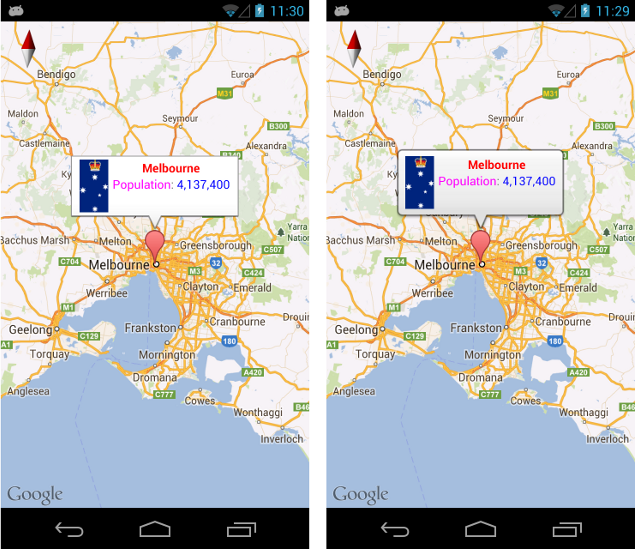
The following image shows some examples of some customized info windows. The image on the left has its contents customized, while the image on the right has its window and contents customized with rounded corners:
GroundOverlays
Unlike markers, which identify a specific location on a map, a GroundOverlay is an image that is used to identify a collection of locations or an area on the map.
Adding a GroundOverlay
Adding a ground overlay to a map is similar to adding a marker to
a map. First, a
GroundOverlayOptions
object is created. This object is then passed as a parameter to the
GoogleMap.AddGroundOverlay method, which will return a
GroundOverlay object. This code snippet is an example of adding a
ground overlay to a map:
BitmapDescriptor image = BitmapDescriptorFactory.FromResource(Resource.Drawable.polarbear);
GroundOverlayOptions groundOverlayOptions = new GroundOverlayOptions()
    .Position(position, 150, 200)
    .InvokeImage(image);
GroundOverlay myOverlay = googleMap.AddGroundOverlay(groundOverlayOptions);
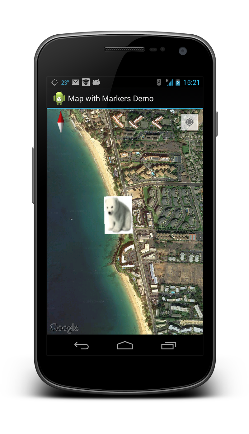
The following screenshot shows this overlay on a map:
Lines, Circles, and Polygons
There are three simple types of geometric figures that can be added to a map:
Polyline - This is a series of connected line segments. It can mark a path on a map or create a geometric shape.
Circle - This will draw a circle on the map.
Polygon - This is a closed shape for marking areas on a map.
Polylines
A Polyline
is a list of consecutive LatLng objects which specify the vertices of
each line segment. A polyline is created by first creating a
PolylineOptions object and adding the points to it. The
PolylineOption object is then passed to a GoogleMap object by calling
the AddPolyline method.
PolylineOption rectOptions = new PolylineOption();
rectOptions.Add(new LatLng(37.35, -122.0));
rectOptions.Add(new LatLng(37.45, -122.0));
rectOptions.Add(new LatLng(37.45, -122.2));
rectOptions.Add(new LatLng(37.35, -122.2));
rectOptions.Add(new LatLng(37.35, -122.0)); // close the polyline - this makes a rectangle.

googleMap.AddPolyline(rectOptions);
Circles
Circles are created by first instantiating a CircleOption object which will specify the center and the radius of the circle in metres. The circle is drawn on the map by calling GoogleMap.AddCircle. The following code snippet shows how to draw a circle:
CircleOptions circleOptions = new CircleOptions ();
circleOptions.InvokeCenter (new LatLng(37.4, -122.1));
circleOptions.InvokeRadius (1000);

googleMap.AddCircle (circleOptions);
Polygons
Polygons are similar to Polylines, however they are not open
ended. Polygons are a closed loop and have their interior filled in.
Polygons are created in the exact same manner as a Polyline, except the
GoogleMap.AddPolygon
method invoked.
Unlike a Polyline, a Polygon is self-closing. The polygon will be closed off by the AddPolygon method by drawing a line which connects the first and last points. The following code
snippet will create a solid rectangle over the same area as the
previous code snippet in the Polyline example.
PolygonOptions rectOptions = new PolygonOptions();
rectOptions.Add(new LatLng(37.35, -122.0));
rectOptions.Add(new LatLng(37.45, -122.0));
rectOptions.Add(new LatLng(37.45, -122.2));
rectOptions.Add(new LatLng(37.35, -122.2));
// notice we don't need to close off the polygon

googleMap.AddPolygon(rectOptions);
Responding to user events
There are three types of interactions a user may have with a map:
Marker Click - The user clicks on a marker.
Marker Drag - The user has long-clicked on a mparger
Info Window Click - The user has clicked on an info window.
Each of these events will be discussed in more detail below.
Marker click events
The MarkerClicked event is raised when the user taps on a marker. This event accepts a GoogleMap.MarkerClickEventArgs object as a parameter. This class
contains two properties:
GoogleMap.MarkerClickEventArgs.Handled– This property should be set totrueto indicate that the event handler has consumed the event. If this is set tofalsethen the default behaviour will occur in addition to the custom behaviour of the event handler.Marker– This property is a reference to the marker that raised theMarkerClickevent.
This code snippet shows an example of a MarkerClick that will change
the camera position to a new location on the map:
void MapOnMarkerClick(object sender, GoogleMap.MarkerClickEventArgs markerClickEventArgs)
{
    markerClickEventArgs.Handled = true;

    var marker = markerClickEventArgs.Marker;
    if (marker.Id.Equals(gotMauiMarkerId))
    {
        LatLng InMaui = new LatLng(20.72110, -156.44776);

        // Move the camera to look at Maui.
        PositionPolarBearGroundOverlay(InMaui);
        googleMap.AnimateCamera(CameraUpdateFactory.NewLatLngZoom(InMaui, 13));
        gotMauiMarkerId = null;
        polarBearMarker.Remove();
        polarBearMarker = null;
    }
    else
    {
        Toast.MakeText(this, $"You clicked on Marker ID {marker.Id}", ToastLength.Short).Show();
    }
}
Marker Drag events
This event is raised when the user wishes to drag the marker. By
default, markers are not draggable. A marker can be set as draggable by
setting the Marker.Draggable property to true or by invoking the
MarkerOptions.Draggable method with true as a parameter.
To drag the marker, the user must first long-click on the marker and then their finger must remain on the map. When the user's finger is dragged around on the screen, the marker will move. When the user's finger lifts off the screen, the marker will remain in place.
The following list describes the various events that will be raised for a draggable marker:
GoogleMap.MarkerDragStart(object sender, GoogleMap.MarkerDragStartEventArgs e)– This event is raised when the user first drags the marker.GoogleMap.MarkerDrag(object sender, GoogleMap.MarkerDragEventArgs e)– This event is raised as the marker is being dragged.GoogleMap.MarkerDragEnd(object sender, GoogleMap.MarkerDragEndEventArgs e)– This event is raised when the user is finished dragging the marker.
Each of the EventArgs contains a single property called P0 that is a
reference to the Marker object being dragged.
Info Window Click events
Only one info window can be displayed at a time. When the user clicks
on an info window in a map, the map object will raise an
InfoWindowClick event. The following code snippet shows how to wire
up a handler to the event:
public void OnMapReady(GoogleMap map)
{
    map.InfoWindowClick += MapOnInfoWindowClick;
}

private void MapOnInfoWindowClick (object sender, GoogleMap.InfoWindowClickEventArgs e)
{
    Marker myMarker = e.Marker;
    // Do something with marker.
}
Recall that an info window is a static View which is rendered as an
image on the map. Any widgets such as buttons, check boxes, or text
views that are placed inside the info window will be inert and cannot
respond to any of their integral user events.

