Integrating location and map functionality in SharePoint
Learn how to integrate location information and maps in SharePoint lists and location-based web and mobile apps for SharePoint, by using the new Geolocation field, and by creating your own Geolocation-based field types based on Geolocation.
What are the location and map features in SharePoint?
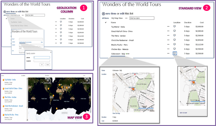
SharePoint introduces a new field type named Geolocation that enables you to annotate SharePoint lists with location information. In columns of type Geolocation, you can enter location information as a pair of latitude and longitude coordinates in decimal degrees or retrieve the coordinates of the user's current location from the browser if it implements the W3C Geolocation API. In the list, SharePoint displays the location on a map powered by Bing Maps. In addition, a new view named Map View displays the list items as pushpins on a Bing Maps Ajax control V7 with the list items as cards on the left pane. Figure 1 summarizes the default location and map features in SharePoint. Together, the Geolocation field and the Map View enable you to give a spatial context to any information by integrating data from SharePoint into a mapping experience, and let your users engage in new ways in your web and mobile apps and solutions.
Important
JSLink based customizations (client-side rendering) are not supported in modern experiences. This includes modern lists and libraries, including JSLink support in the list view web parts of the modern pages. Client-side rendering is supported in the classic experiences in SharePoint Online or in on-premises.
Note
An MSI package named SQLSysClrTypes.msi must be installed on every SharePoint front-end web server to view the geolocation field value or data in a list. This package installs components that implement the new geometry, geography, and hierarchy ID types in SQL Server 2008. By default, this file is installed for SharePoint Online. However, it is not for an on-premises deployment of SharePoint. You must be a member of the Farm Administrators group to perform this operation. To download SQLSysClrTypes.msi, see Microsoft SQL Server 2008 R2 SP1 Feature Pack for SQL Server 2008, or Microsoft SQL Server 2012 Feature Packfor SQL Server 2012 in the Microsoft Download Center.
Figure 1.Summarized view of the default location and map features

What can you do with the location and map features?
The location and map features in SharePoint provide unique opportunities for developers to incorporate location, maps, and proximity search features into their web and mobile apps and solutions. Table 1 contains some basic tasks that help you integrate location and map features in your apps and solutions.
Table 1. Basic tasks for integrating location and maps functionality
| Task | Description |
|---|---|
| How to: Set the Bing Maps key at the web and farm level in SharePoint |
SharePoint uses Bings Maps to render the map of the location. To be able to use the Bing Maps feature, you need to create a Bing Maps key and set the key at the web or farm level. The article shows the various ways you can set the key in SharePoint and when to choose which option. You see an error message on the map if you do not use a valid Bing Maps key or if a key is not set at the web that contains the list or at the farm level. |
| How to: Add a Geolocation column to a list programmatically in SharePoint |
The Geolocation column is not available in SharePoint lists for users, by default. To add the column to a SharePoint list, you need to write code. In this topic, learn how to add the Geolocation field to a list programmatically. |
| How to: Extend the Geolocation field type using client-side rendering |
You can provide your own rendering to default user interface (UI.md), logic, and behavior of the Geolocation field by creating custom field types that derive from the Geolocation field. SharePoint simplifies the creation of custom field types by enabling you to run JavaScript by providing a new JSLink property in the Geolocation field class, which points to a custom .js file that renders the field. Note: The JSLink property is not supported on Survey or Events lists. A SharePoint calendar is an Events list. |
See also
How to: Add a Geolocation column to a list programmatically in SharePoint
How to: Set the Bing Maps key at the web and farm level in SharePoint
How to: Extend the Geolocation field type using client-side rendering
How to: Integrate maps with Windows Phone apps and SharePoint lists
Use the SharePoint location field type in mobile applications