geo_point_in_circle()
適用対象: ✅Microsoft Fabric✅Azure データ エクスプローラー✅Azure Monitor✅Microsoft Sentinel
地理空間座標が地球の円の内側にあるかどうかを計算します。
構文
geo_point_in_circle(p_longitude, p_latitude, pc_longitude, pc_latitude, c_radius)
構文規則について詳しく知る。
パラメーター
| 件名 | タイプ | Required | 説明 |
|---|---|---|---|
| p_longitude | real |
✔️ | 地理空間座標の経度値 (度単位)。 有効な値は実数で、[-180, +180] の範囲です。 |
| p_latitude | real |
✔️ | 地理空間座標の緯度の値 (度単位)。 有効な値は実数で、[-90, +90] の範囲です。 |
| pc_longitude | real |
✔️ | 円中心地理空間座標経度値 (度単位)。 有効な値は実数で、[-180, +180] の範囲です。 |
| pc_latitude | real |
✔️ | 円の中心の地理空間座標の緯度の値を度単位で指定します。 有効な値は実数で、[-90, +90] の範囲です。 |
| c_radius | real |
✔️ | 円の半径 (メートル単位)。 有効な値は正の整数で指定する必要があります。 |
返品
地理空間座標が円の内部にあるかどうかを示します。 座標または円が無効な場合、クエリは null 結果を生成します。
Note
例
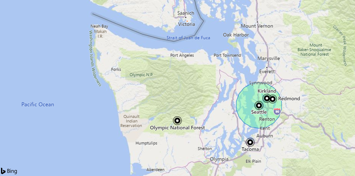
次の例では、[-122.317404, 47.609119] 座標の中心である半径 18 km の円で定義されている領域内のすべての場所を検索します。

datatable(longitude:real, latitude:real, place:string)
[
    real(-122.317404), 47.609119, 'Seattle',                   // In circle
    real(-123.497688), 47.458098, 'Olympic National Forest',   // In exterior of circle
    real(-122.201741), 47.677084, 'Kirkland',                  // In circle
    real(-122.443663), 47.247092, 'Tacoma',                    // In exterior of circle
    real(-122.121975), 47.671345, 'Redmond',                   // In circle
]
| where geo_point_in_circle(longitude, latitude, -122.317404, 47.609119, 18000)
| project place
出力
| 場所 |
|---|
| シアトル |
| Kirkland |
| Redmond |
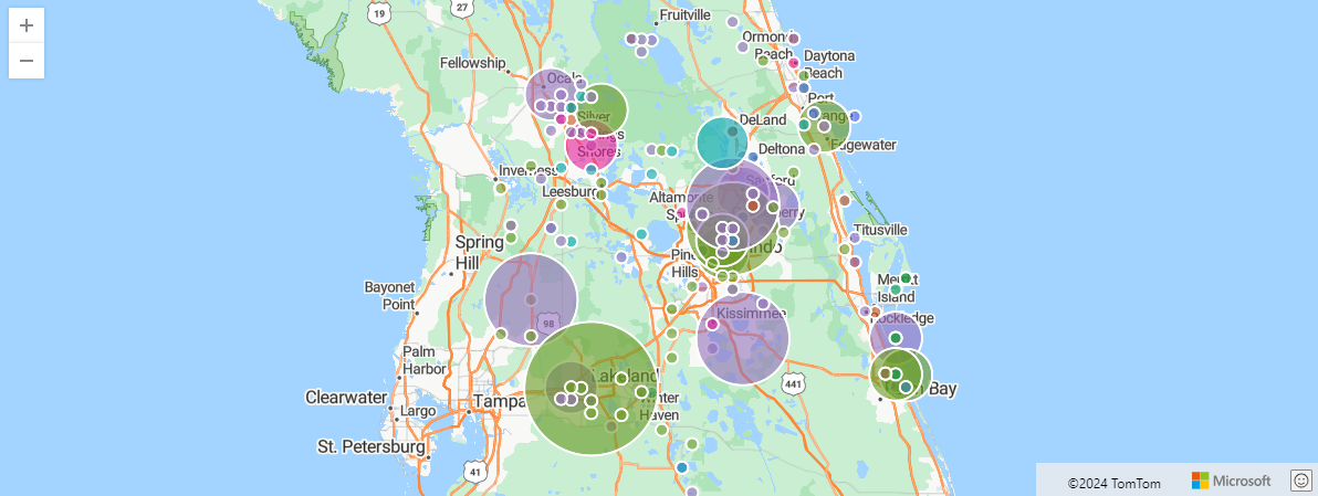
次の例では、オーランドで Storm イベントを検索します。 イベントは、オーランド州の座標内100 kmによってフィルター処理され、イベントの種類とハッシュによって集計されます。
StormEvents
| project BeginLon, BeginLat, EventType
| where geo_point_in_circle(BeginLon, BeginLat, real(-81.3891), 28.5346, 1000 * 100)
| summarize count() by EventType, hash = geo_point_to_s2cell(BeginLon, BeginLat)
| project geo_s2cell_to_central_point(hash), EventType, count_
| render piechart with (kind=map) // map pie rendering available in Kusto Explorer desktop
出力

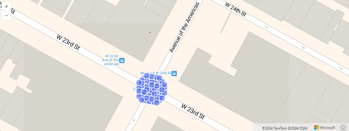
次の例は、特定の場所から 10 メートル以内のニューヨーク市のタクシー乗車を示しています。 関連するピックアップは、ハッシュによって集計されます。
nyc_taxi
| project pickup_longitude, pickup_latitude
| where geo_point_in_circle( pickup_longitude, pickup_latitude, real(-73.9928), 40.7429, 10)
| summarize by hash = geo_point_to_s2cell(pickup_longitude, pickup_latitude, 22)
| project geo_s2cell_to_central_point(hash)
| render scatterchart with (kind = map)
出力

次の例では、true が返されます。
print in_circle = geo_point_in_circle(-122.143564, 47.535677, -122.100896, 47.527351, 3500)
出力
| in_circle |
|---|
| true |
次の例では、false が返されます。
print in_circle = geo_point_in_circle(-122.137575, 47.630683, -122.100896, 47.527351, 3500)
出力
| in_circle |
|---|
| false |
次の例では、座標入力が無効なため、null 値の結果が返されます。
print in_circle = geo_point_in_circle(200, 1, 1, 1, 1)
出力
| in_circle |
|---|
次の例では、無効な円の半径入力が原因で null 結果が返されます。
print in_circle = geo_point_in_circle(1, 1, 1, 1, -1)
出力
| in_circle |
|---|