Happy Earth Day, 2009
Happy Earth Day, my fellow Virtual Earthlings. What better way to celebrate Earth Day than to highlight a couple Virtual Earth applications? Ok, I could think of a few ways, but since we’re all stuck inside on Earth Day….wait, maybe I should go work outside today….I’ll give you some relevant sites that have integrated Microsoft Virtual Earth into their applications to help conserve Mother Earth and give you a reason to feel good about working inside...little comfort, I know.
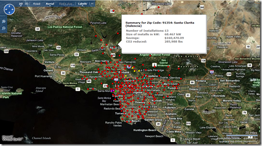
Los Angeles County just announced their Solar Map project which leverages Virtual Earth to allow homeowners and businesses to go online to determine if their properties are good candidates for solar power. The program uses roof size, pitch and shading from nearby trees, buildings and mountains to provide a building’s solar potential and the potential value of installing solar panels. By typing in an address, a person will learn the property’s roof size, area suitable for solar panels, electricity produced, electricity savings, carbon reduction, nearby solar installations and case studies, available rebates from utility companies, and information about installers.
Within the application, you can hover over the different pushpins (dots) which represent different entity types – Government (green), Residential (yellow), Commercial (pink), Schools/libraries (cyan), Non-profits (blue), and Zip Code Summaries (red). Each pushpin will provide you with a summary of the solar usage for the respective entity. Information such as Number of Installations – how many houses have solar panels installed; Size of installs in kW – how many kilowatts the respective installations are producing; Savings – how many dollars the respective installation is saving by using solar; and, CO2 reduced – how many pounds of CO2 are being kept out of the environment by using solar.
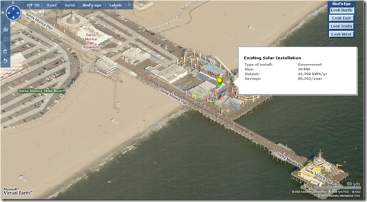
If you zoom down a bit, you’ll see the dots turn into markers (better aesthetics, you see). Now, flip on some Bird’s eye and you can see just how aerial photography from Virtual Earth just makes all the difference in the world to visualize a specific location. So, if you live in LA County, go get yourself some solar panels, throw them on your roof, start saving money and for the excess power you have (for crying out loud you have plenty of sun, LA) sell it back to the power companies and make some money. It’s easy people. And, the LA County Solar Map web site even provides you with links to find a solar panel installer, so you’re really running out of excuses to not get on solar and save the Earth from CO2 destruction! For more information about the LA County Solar Map project, check out Jerry Skaw’s Virtual Earth for Public Sector blog.
What else is going on this wonderful Earth Day?
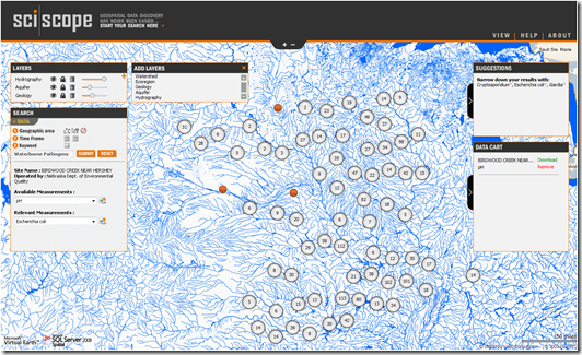
 The Microsoft Research Team launched a new search engine called SciScope which is focused exclusively on rich environmental information presented on a Microsoft Virtual Earth map. The site facilitates data discovery and retrieval from millions of sensors that monitor the quality of the environment. SciScope has data from over 9.5 million sensors and 1.7 million locations that visualize information on a Virtual Earth map while leveraging SQL Server 2008 to handle the queries. Users can easily click to add layers such as Watershed, Ecoregion, Geology, Aquifer and Hydrography to view data overlays respective to the information.
You can add up to 3 layers at any given time. To remove a layer, simply click the garbage can icon next to it. To add a layer, simply click the plus sign and select the respective layer you want. Additionally, you can query the data within the layer by specifying a polygon using the polygon drawing tool. To filter your result list even further, you can then limit your search by time frame from between January 1, 1985 and now. Finally, you can search by keywords to really get down to what you’re looking for. There’s an AJAX query happening, so as you type results will populate below the search box. The following video provides the best overview of all the features of the site, so watch it first to fully understand how the site works.
“If you’re a scientist, before you can even begin working with your data, you have to do all the work of making it compatible,” says Bora Beran, an environmental scientist who is overseeing the SciScope project at Microsoft Research. “SciScope can dramatically reduce the time and effort necessary to discover and assemble a dataset.”
SciScope will continue to evolve over time, so be sure to check back for additional updates to the site. For additional information, you can read “SciScope Helps Scientists In Quest for Environmental Data.”
Happy Earth Day…week…month…year…life.
CP
Comments
- Anonymous
May 28, 2009
That is incredible, the detail that can be viewed is truly amazing!


