| Augmented Reality applications need a Web Service Back-End. Here is a 90-Day No obligation, totally free offer to use Windows Azure as your web service for Windows 8 Clients. |
You get: Compute / 750 small compute hours per month, Web sites / 10 web sites, Mobile services / 10 mobile services, Relational database / 1 SQL database, SQL reporting / 100 hours per month, Storage / 35GB with 50,000,000 storage transactions, Bandwidth / unlimited inbound & 25GB outbound, CDN / 20GB outbound with 500,000 transactions, Cache / 128MB, Service bus / 1,500 relay hours and 500,000 messages |
https://www.microsoft.com/click/services /Redirect2.ashx?CR_CC=200114759 |
| Step 0: What we will build. Augmented Reality, Windows 8, and Cloud Computing–How to implement with real code |
High level introduction to our finished application. |
https://blogs.msdn.com/b/brunoterkaly/archive/2012 /11/05/step-0-what-we-will-build- augmented-reality-windows-8-and-cloud-computing-how-to-implement-with-real-code.aspx# |
| Step 1–Augmented Reality, Windows 8, and Cloud Computing–How to implement with real code |
Introduction. What is Augmented Reality |
https://blogs.msdn.com/b/brunoterkaly/archive/2012/10/29/ step-1-augmented-reality-windows-8-and-cloud-computing- how-to-implement-with-real-code.aspx# |
| Step 2–Augmented Reality, Windows 8, and Cloud Computing–How to implement with real code |
Building the first part of our Azure back-end. |
https://blogs.msdn.com/b/brunoterkaly/archive/2012/10/30/ step-2-augmented-reality-windows-8-and- cloud-computing-how-to-implement-with-real-code.aspx# |
| Step 3–Augmented Reality, Windows 8, and Cloud Computing–How to implement with real code (Implementing the Cloud Back-End) |
This post provides all source code and explanation for the Azure back-end. This is the back-end for the augmented reality Windows 8 Client. |
https://blogs.msdn.com/b/brunoterkaly/archive/2012/11/05 /step-3-augmented-reality-windows-8-and-cloud-computing-how- to-implement-with-real-code-implementing-the-cloud-back-end.aspx# |
| Step 4–Augmented Reality, Windows 8, and Cloud Computing–How to implement with real code ... |
This post provides all source code and explanation for the Windows 8 Client (Augmented Reality Demo). The augmented reality Windows 8 Client calls into the Azure back-end described in step 3 above. |
https://blogs.msdn.com/b/brunoterkaly/archive/2012/11/06/ step-4-augmented-reality-windows-8-and-cloud-computing-how-to-implement-with-real-code-implementing-the- windows-8-client.aspx# |
| Source Code - Web Service Back End |
This is the Windows Azure Project that Windows 8 Clients call into |
https://sdrv.ms/Qoqb1J |
| Source Code - Windows 8 Client |
This is the Augmented Reality Windows 8 Client |
https://sdrv.ms/T38uBC |
This is the finished augmented reality client.

- I have completed the code. Now it is time to blog about it.
- Notice that it has augmented reality data overload on top of a live photo
- It also has a satellite image
- You can use the GPS simulator to change locations
- My system doesn't have a GPS device and yours probably does not either
- The information displayed is a mash-up of the Google Maps and information from the National Oceanic and Atmospheric Administration
- I will provide all source code.
A zoom-in of the augmented reality data

- A little better resolution to see what is happening.
This is a Windows Azure Back-end
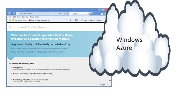
- It is hosted in a Microsoft Data Center
- The image above is running locally (in an emulator)
- This running application can be scaled to meet any demand by Windows 8 clients
- The style of Azure application is (MVC Web API), described in future posts
The application architecture
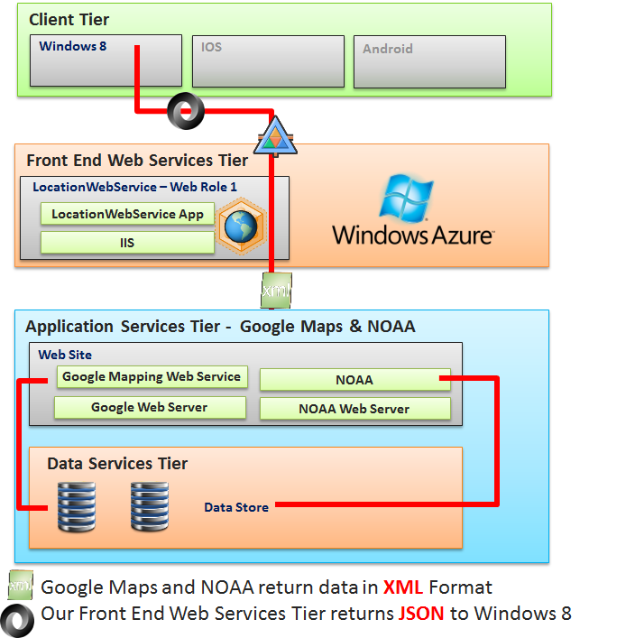
- We will build a Windows 8 Client in a future post
- That is where the augmented reality is actually taking place
- Our front end web services tier supports our Windows 8 Client
- We will deploy this tier to a Microsoft Data Center
- The Application Services Tier will be Google Maps and the National Oceanic Atmospheric Agency (NOAA)
- This could be architected for even greater scale.
- You could leverage message queues and background processes (worker roles)
- It does currently leverage threading for parallel look ups of data mash-ups
- This means I call Google Maps and NOAA at the same time using .NET Tasks
- The next step is to finish building the cloud server.
- From there I will show the code behind the Windows 8 client
Focusing on the Cloud Back-End
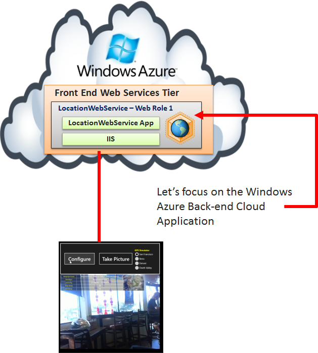
- In Step 2 you could see how to create:
- A Windows Azure Cloud Project with:
1 MVC 4 Web Role
Web Role Type = ASP.NET Web API
Starting the server
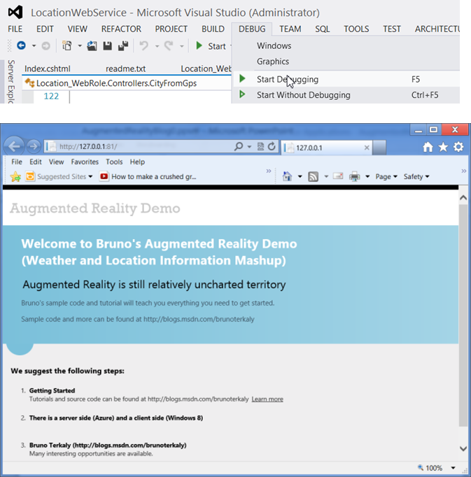
- It is a Windows Azure Cloud app
- It was previously blogged about here
- But we need to add more to this project.
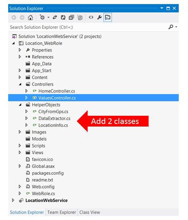
Visual Studio 2012 - Solution Explorer
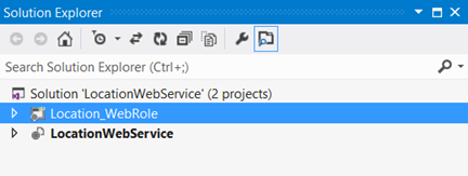
- You can see one solution with two projects:
- Project 1: Location_WebRole
- This is where we do all the work, adding code
- Project 2: LocationWebService
- This is the configuration project that allows us to scale our application once we deploy it to the cloud.
How to build the Azure Cloud Application Back-End
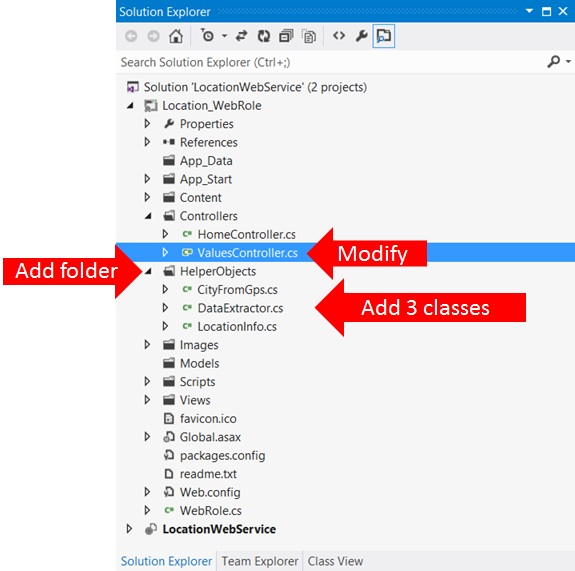
- We are going to do 3 things here:
- Modify Existing Files
- Add a folder to hold our code
- Add new classes
- Modify Files
- Add Folder
- Add classes (HelperObjects)
- CityFromGps.cs
- DataExtractor.cs
- LocationInfo.cs
ValuesController.cs
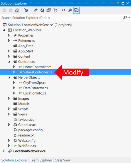
- This is the entry point for clients making http calls
- We only need one method in there.
- The Get() method responds to Windows 8 client requests
| ValuesController.cs |
| 1 2 3 4 5 6 7 8 9 10 11 12 13 14 15 16 17 18 19 20 21 22 | using System; using System.Collections.Generic; using System.Linq; using System.Net; using System.Net.Http; using System.Web.Http; using Location_WebRole.HelperObjects; namespace Location_WebRole.Controllers { public class ValuesController : ApiController { // location contains lat/long, "37.788345,-122.404679", for example public LocationInfo Get(string location) { string[] columns = location.Split(','); CityFromGps city = new CityFromGps(); return city.ReverseGeoLoc(columns[1], columns[0]); } } } |
| Line 11 |
ValuesController.cs was built by Visual Studio when we created the project. It is the entry point for Windows 8 client requests. |
| Line 14 |
We have just one Get() method. It is executed automatically by Windows 8 clients. The Windows client will issue the commands in Table A |
| Line 16 |
Split the GPS coordinates. columns[0] will be 37.785530, and columns[1] will be -122.405672 |
| Line 17 |
Our helper class that actually does all the processing |
| Line 18 |
Return the JSON answers back to the Windows 8 Client |
| Our cloud project running in emulator |
https://127.0.0.1:81/api/values?location=37.785530,-122.405672 |
| Our cloud project running in a Microsoft Data Center |
https://locationwebservice.cloudapp.net/api/values?location=37.785530,-122.405672 |
The main workhorse - CityFromGps.cs

- This class does most of the hard work.
- It uses concurrent programming techniques to conduct data mash-ups.
| CityFromGps.cs |
| 1 2 3 4 5 6 7 8 9 10 11 12 13 14 15 16 17 18 19 20 21 22 23 24 25 26 27 28 29 30 31 32 33 34 35 36 37 38 39 40 41 42 43 44 45 46 47 48 49 50 51 52 53 54 55 56 57 58 59 60 61 62 63 64 65 66 67 68 69 70 71 72 73 74 75 | using System; using System.Collections.Generic; using System.IO; using System.Linq; using System.Net.Http; using System.Net.Http.Formatting; using System.Text; using System.Threading.Tasks; using System.Xml; using Location_WebRole.HelperObjects; namespace Location_WebRole.Controllers { // My custom string manipulator. Nows how to parse all the XML structures public class CityFromGps { // Method that does all the lookups based on longitude and latitude. public LocationInfo ReverseGeoLoc(string longitude, string latitude) { // Return data is LocationInfo LocationInfo loc_info = new LocationInfo(); DataExtractor de = new DataExtractor(); // a helper class to make this threading code readable loc_info.longitude = longitude; loc_info.latitude = latitude; try { // // Get Data // XmlDocument[] xmldocs = new XmlDocument[3] { new XmlDocument(), new XmlDocument(), new XmlDocument() }; Task<string>[] tasks = new Task<string>[3] { Task<string>.Factory.StartNew(() => { xmldocs[0].Load("http://maps.googleapis.com/maps/api/elevation/xml?locations=" + latitude + "," + longitude + "&sensor=false"); XmlNodeList weatherList = xmldocs[0].SelectNodes("//ElevationResponse/result"); loc_info.elevation = (Convert.ToDouble(weatherList[0]["elevation"].InnerText) * 3.2808399).ToString(); return ""; }), Task<string>.Factory.StartNew(() => { // Get Transit and Neighborhood Info xmldocs[1].Load(string.Format("http://maps.googleapis.com/maps/api/geocode/xml?latlng={0},{1}&sensor=false", latitude, longitude)); loc_info.bus_and_neighborhood = de.GetTransitAndNeighborhood(xmldocs[1]); return ""; }), Task<string>.Factory.StartNew(() => { // Get Weather Info xmldocs[2].Load(string.Format("http://graphical.weather.gov/xml/sample_products/browser_interface/ndfdXMLclient.php?lat={0}&lon={1}&product=time-series&maxt=maxt&mint=mint", latitude, longitude)); loc_info.max_temp = de.GetMaxTemp(xmldocs[2]); loc_info.min_temp = de.GetMinTemp(xmldocs[2]); return ""; }) }; //Block until all tasks complete. This is much faster. Task.WaitAll(tasks); return loc_info; } catch (Exception ex) { loc_info.error = "(Location lookup failed: ) " + ex.Message; return loc_info; } } } } |
| Lines 1 to 10 |
Needed using statements |
| Line 15 |
CityFromGps class that we've added |
| Line 19 |
The ReverseGeoLoc() method. It returns JSON-formatted data for LocationInfo (a class we still need to add). It takes two parameters, logitude and latitude. It will perform a number of look ups against other web services, such as Google Maps and NOAA (NOAA - National Oceanic and Atmospheric Administration) |
| Lines 22 and 23 |
Instantiate our helper objects. LocationInfo will contain the results of our data lookups. It will hold temperature, elevation, city, etc. |
| Line 33 |
The XmlDocument objects that will be used for the lookups against web services |
| Lines 37, 44, 51 |
3 Tasks (concurrent threads if enough cores) are launched, working in parallel, performing lookups against web services. |
| Lines 40-41, 47-48, 54-56 |
The actual lookups. This where the actual call to Google Maps and NOAA takes place. |
| Line 61 |
Wait for all tasks to complete. This line ensures that we continue only after all 3 tasks have completed. |
| Line 62 |
Return the LocationInfo object, which is now populated with data. The ASP.NET Web API automatically makes this a JSON formatted object. |
DataExtractor.cs and LocationInfo.cs
- DataExtractor.cs abstracts the complexity of parsing XML and getting the answers we need
- Such as max temp, min temp, elevation, etc
- LocationInfo.cs represents the data going back to the Windows 8 client
| DataExtractor.cs |
| 1 2 3 4 5 6 7 8 9 10 11 12 13 14 15 16 17 18 19 20 21 22 23 24 25 26 27 28 29 30 31 32 33 34 35 36 37 38 39 40 41 42 43 44 45 46 47 48 49 50 51 52 53 54 55 56 57 58 59 60 61 62 63 64 65 66 67 68 69 70 71 72 | using System; using System.Collections.Generic; using System.Linq; using System.Web; using System.Xml; namespace Location_WebRole.Controllers { public class DataExtractor { public string GetTransitAndNeighborhood(XmlDocument doc) { string result = ""; bool foundneighborhood = false; bool foundbus = false; XmlNodeList xnList = doc.SelectNodes("//GeocodeResponse/result/address_component"); foreach (XmlNode xn in xnList) { try { switch (xn["type"].InnerText) { //Add whatever you are looking for below case "bus_station": { if (foundbus) break; if (result != "") result += ", "; result += "Bus: " + xn["long_name"].InnerText; foundbus = true; break; } case "neighborhood": { if (foundneighborhood) break; if (result != "") result += ", "; result += "Neighborhood: " + xn["long_name"].InnerText + " (" + xn["short_name"].InnerText + ")"; foundneighborhood = true; break; } default: break; } } catch (Exception e) { } } return result; } internal string GetMaxTemp(XmlDocument doc) { XmlNodeList xnList = doc.SelectNodes("//dwml/data/parameters/temperature"); return xnList[0]["value"].InnerText; // offset 0 is max temps } internal string GetMinTemp(XmlDocument doc) { XmlNodeList xnList = doc.SelectNodes("//dwml/data/parameters/temperature"); return xnList[1]["value"].InnerText; // offset 1 is min temps } } } |
| Line 11 |
The method that returns the bus stop and neighborhood information. |
| Line 60 |
The method that returns the max temperature info from NOAA |
| Line 65 |
The method that returns the min temperature info from NOAA |
| LocationInfo.cs |
| 1 2 3 4 5 6 7 8 9 10 11 12 13 14 15 16 17 18 19 20 21 22 | using System; using System.Collections.Generic; using System.IO; using System.Linq; using System.Net.Http; using System.Net.Http.Formatting; using System.Web; namespace Location_WebRole.HelperObjects { public class LocationInfo { // Data we will lookup public string latitude { get; set; } public string longitude { get; set; } public string elevation { get; set; } public string bus_and_neighborhood { get; set; } public string max_temp { get; set; } public string min_temp { get; set; } public string error { get; set; } } } |
| Line 11 |
Our LocationInfo structure. This will be returned back to the Windows 8 client, populated with data. The ASP.NET Web API will automatically convert this object to JSON format. |
Conclusion
| |
The next series of posts will focus on the Windows 8 client. |
- Anonymous
February 11, 2013
The comment has been removed


