BC Hydro
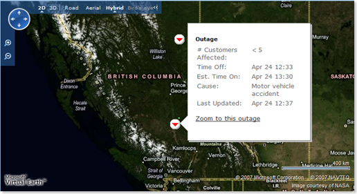
 More on the utilities front - BC Hydro is using Virtual Earth to show their customers outages that they are aware of in British Columbia. First off - I love this. I lost power in my house in Woodinville, WA when the wind storms 16 months ago knocked out power for most of the eastside of Seattle. Puget Sound Energy had posted a PDF of outages they were aware of, but the map was a static PDF that no one ever updated after it was first published. I had no idea when my electricity was going to be back on, nor did I know if they were even aware that 25 trees were lain across the wires at the top of my neighborhood. Providing a dynamic solution (such as what BC Hydro has provided) allows customers a few different ways (list, mobile and most importantly map views) to visualize that "Yes, we know you lost power, we're working on it and we plan to fix it by 'this' time."
The BC Hydro map site specifically provides information about the number of customers affected, the time the power turned off, the estimated time the power will return, when the page was last updated and in a unique spin what caused the outage! Now, this is simply awesome to put that information out there. Currently, there are only 2 outages (which is what you want from your power company), but I love that I can see that the cause of the accident was someone crashing their car into a pole. You can also zoom down to see the perimeter of the area affected clicking the "Zoom to this outage" link. I was a little embarrassed that for these two incidents we only have 15 meter satellite imagery, so I couldn't see the land base in Aerial/Hybrid view but when I switched to Road view it works great. Don't worry British Columbia, we'll get you the imagery you need soon enough.
Comments
- Anonymous
April 25, 2008
PingBack from http://house-sites2008.freehostia.com/?p=3958
