Bing vs Google – The Showdown of the Maps – A student perspective
I’m a big fan when it comes to Maps. I have no idea why mapping online is so cool to me, but it’s one of the things I use a lot. Today I’ve decided to compare Bing and Google Maps both side by side and see who is the winner! While Wikipedia has a great comparison, I will be conducting this from an end user’s perspective. (Both have enterprise versions which you can look at online, Bing Maps at https://www.microsoft.com/maps/default.aspx, Google Maps at https://www.google.com/enterprise/earthmaps/maps.html)
For this I’m using Bing Maps Silverlight Beta and Standard Google Maps, using both IE8 and Firefox.
Before we jump into the comparisons, lets have a look at the general feature set of each.
Bing Maps (Beta)
- Road + Satellite + “Birds Eye” View
- 3D models of major US cities
- Streetside view with Flickr picture overlays
- Photosynth integration
- Driving directions + Traffic Information
Google Maps
- Road + Satellite + Terrain views
- Streetview
- Panorama integration
- Driving directions + Traffic Information
- Mobile Map Applications
Comparison:
User experience
Bing uses the power of Silverlight to give you a much smoother loading experience and gives way to more interactive features such as Flickr, Photosynth and the upcoming Worldwide Telescope, inside the platform. Bing maps automatically changes the style of map as you zoom in and out to give you the best map style. You have the option to change this to manual so you can control which view you see at all times.
As you scroll around the map, the left hand bar dynamically updates the current weather, pictures and Photosynths for the current area.
Google maps makes heavy use of JavaScript, this leads to the transitions feeling a lot less smooth and more choppy when zooming. Google Maps gives you 3 buttons on the top right of the map to switch between “Map – Satellite – Terrain” views. Unlike Bing maps, the left hand side doesn’t serve any purpose when you are scrolling around the map.
Winner – Bing Maps.
Bing maps beta at this early stage feels much more feature filled. Everything is one click away in the left hand bar. I can view Photosynths, Driving directions, Pictures, Current weather, Restaurants and Hotels. Straight away it feels more interactive, I can connect with content I want and I don’t have to go searching for it. The power of Silverlight makes the user experience very smooth when moving around the map and give us cool eye candy effects when moving from different views.
Google Maps on the other hand sticks to its trademark basic look, giving us a simple experience with just the map and some links for Get Directions and My Maps. The JavaScript makes it feel very choppy zooming in and out of the map.
Location Search Accuracy
One of the most important things for a map is accuracy, so lets do a couple of searches. Lets start with one for Seattle, WA. Both find it very easily and the only real difference is, again, what content is featured in the left hand bar.
Bing features:
- Information from Wikipedia,
- Current weather
- Featured Photosynth’s
- Popular categories of search for that area
As well as a “What's nearby” button to expand your search into hotels, restaurants, clicking on the > expands the information on Seattle to include Pictures, Videos, Local news, a 4 day weather forecast and a list of Popular landmarks, with text from Wikipedia.
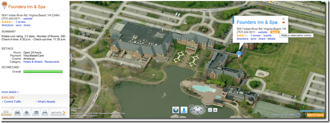
Searching a hotel on Bing is very cool too. It gives you a Summary of details about the hotel, such as check in times, payments methods, cuisines types and you can even make a booking from the Map!!
Google features:
- Links to places
- User created maps
- Random Photos
Clicking on the “more info” link brings us to a second page with photos, videos and popular places.
Lets try somewhere else that's a little less known.
Playa Blanca (Lanzarote, Canary Islands)
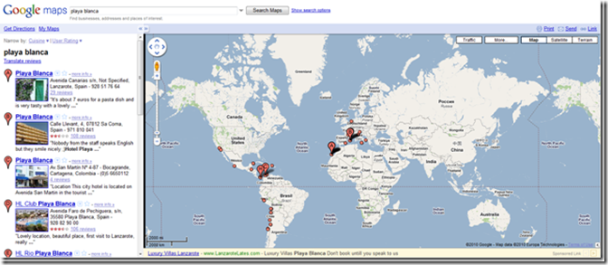
Bing maps brings me straight to the centre of Playa Blanca, giving me the current weather, some information from Wikipedia on the town and the popular categories of searches for that area, while Google lists over 351 results (Yes, 351 Results) from all over the world, some of which aren’t places at all, but are hotels and restaurants.
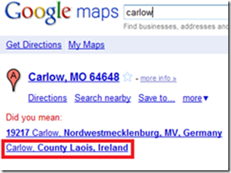
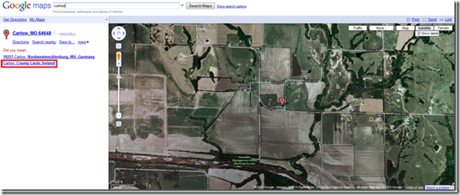
Lets do one more – This time Google maps should be the winner, as Carlow is set as my Default location, but would you believe Google can’t find my default location and sent me off to some place in the U.S?!? Someone has to have a red face over that!
I also want to point out that fact that Google gives the completely wrong area code for the “Did you mean” . Carlow is in County Carlow, not County Laois, as Google suggests here.
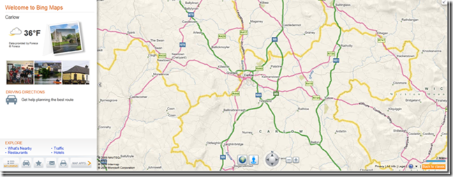
Bing maps ( with no Default location set), finds Carlow first time and zooms straight into the centre of town.
Winner – Bing Maps
No real contest here, Bing maps has a better search with more information available to you about the area you’ve searched for without overcrowding you with information. Google completely let me down on the “Playa Blanca” search with 351 results!?
Google even has trouble finding my default location and then suggests the wrong area code for the place I’m searching for, while Bing finds it straight away and flies straight to the centre of town. This is a big point Google need to work on. The most important thing for a map is to find the right place!
And, as a sidenote, Bing doesn’t put ad’s into it’s maps or the more information page, unlike Google, who do.
Driving Directions
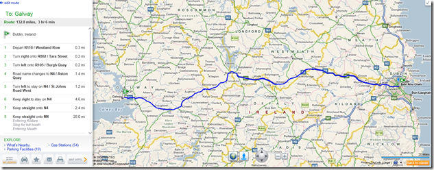
Bing – 132.8 mi – about 3 hours 6 mins
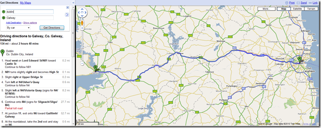
Google – 134.0 mi – about 2 hours 48 mins
Winner – Draw
Both Google and Bing offer nearly the exact same route, though Google claims its 1.2 miles longer and Bing claims it will take 18 minutes longer than Google do. Its worth noting that Bing maps has shorter, simpler to follow directions.
Satellite Image Resolution
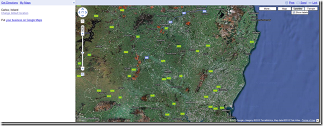
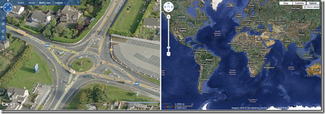
These shots are taken in Carlow, Ireland, (after I helped Google find it) Bing is the left hand side of the image and we can clearly see the resolution is both higher and sharper. These images are also more up to date compared to Google maps are. In these screen grabs, Google is at least 3 years behind with the images, while Bing is about a year.
Bing maps also lets you zoom in further on the maps. Here we can see what happens if we try to zone into the max on both Google and Bing maps. Bing gets into the max while Google shows the No imagery please zoom out!
If we zoom in every closer, Bing will transition us to the Birds eye view mode, which is a close up isometric view of the area, which can be viewed from either North, South, East and West with data for 180 locations worldwide. Google Labs are testing a feature like this on a very small scale (currently only 8 places in U.S)
In major US cities, the birds eye view becomes layered with 3D models of the buildings give a cool “Sim city” style perspective, which fade into the real pictures as you keep zooming in. If we take New York as an example, we can see how each display the Empire State Building.
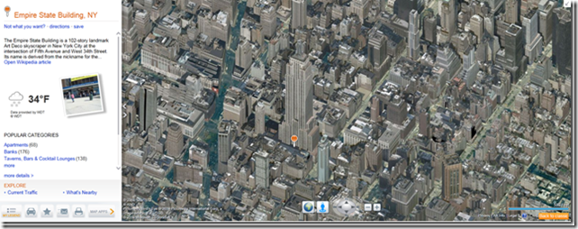
(Image of the Empire State Building in New York)
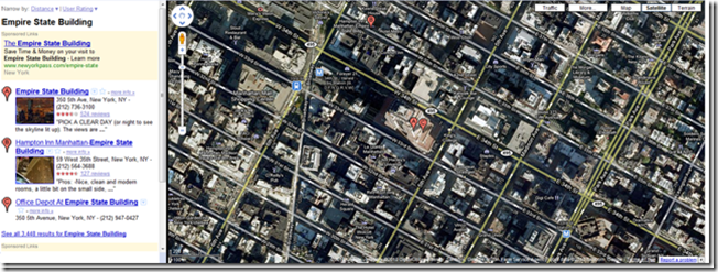
Google Maps does have a view which Bing has left out, its called Terrain view. Terrain view allows users to see the difference ground heights and terrain. This can be very useful data for mountain climbers and people who run trails.
Winner – Bing Maps
More up to date, better quality of images and birds eye view (the 3D models are a really nice touch) make Bing maps a clear winner . (I know people will argue that other places are more up to date in Google and I agree, but I’m judging on my experience of the places I’ve lived, and Bing is more up to date).
Streetside Vs Streetview
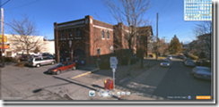
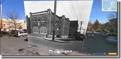
Both Bing and Google have a Streetside view, which is where panoramic images taken from the top of a car and stitched together so a user can view the street as if one was standing there. As we can see in the 3 comparison shots below, Bing is a clear winner. The shots are clearer with a higher level of detail and what's not shown in the pictures but you will notice using the maps, is that Bing maps has the spacial data in place, making moving through the maps feel more alive and 3D.
In this picture we see the Riverwalk Mall outside the New Orleans convention centre.
![clip_image003[6] clip_image003[6]](https://msdntnarchive.z22.web.core.windows.net/media/TNBlogsFS/BlogFileStorage/blogs_msdn/springboard/WindowsLiveWriter/BingvsGoogleTheShowdownoftheMapsAstudent_100A/clip_image003%5B6%5D_4f9ca03b-7f86-429e-9b7d-b5b40ad27c5e.png)
More comparisons
![clip_image004[6] clip_image004[6]](https://msdntnarchive.z22.web.core.windows.net/media/TNBlogsFS/BlogFileStorage/blogs_msdn/springboard/WindowsLiveWriter/BingvsGoogleTheShowdownoftheMapsAstudent_100A/clip_image004%5B6%5D_3f00d934-9c04-4fca-b413-c4881eeb4f42.png)
![clip_image005[6] clip_image005[6]](https://msdntnarchive.z22.web.core.windows.net/media/TNBlogsFS/BlogFileStorage/blogs_msdn/springboard/WindowsLiveWriter/BingvsGoogleTheShowdownoftheMapsAstudent_100A/clip_image005%5B6%5D_58f3cd59-7ae9-4088-830f-646e0ec6499b.png)
![clip_image006[4] clip_image006[4]](https://msdntnarchive.z22.web.core.windows.net/media/TNBlogsFS/BlogFileStorage/blogs_msdn/springboard/WindowsLiveWriter/BingvsGoogleTheShowdownoftheMapsAstudent_100A/clip_image006%5B4%5D_e712162a-2fc2-410b-92f4-4f481fd6275b.png)
![clip_image007[4] clip_image007[4]](https://msdntnarchive.z22.web.core.windows.net/media/TNBlogsFS/BlogFileStorage/blogs_msdn/springboard/WindowsLiveWriter/BingvsGoogleTheShowdownoftheMapsAstudent_100A/clip_image007%5B4%5D_b4e6d39f-228f-4432-a7dc-6acc666d9cbe.png)
(Bridge to M.I.T)
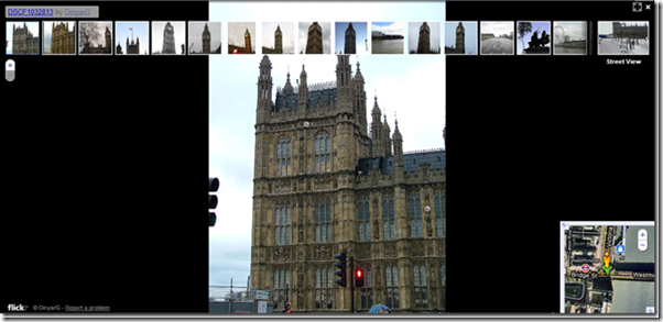
Bing maps also now features Flickr integration into it’s offering, grabbing geo-tagged photos from Flickr, then relating them to the Streetside imagery. This is very cool stuff as it allows for the layering of historical imagery on top of the street imagery, so people can go back in time and see a location as it existed decades ago, before the modern pictures of it where taken for Streetside.
Google maps have added a version on Streetview called “user images” using images from Panoramio. Google’s version does have the advantage of having much more photos since they bought Panoramio, but it doesn’t feel as smooth as Bing Maps as pictures are presented as a slideshow and are not layered on top of Streetview images.
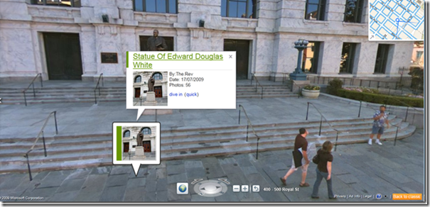
If this wasn’t enough, Bing Maps also integrates Photosynth’s straight into StreetSide, so as you explore the city you will see icon indicating a Photosynth. From this icon, you can jump straight into a Photosynth, explore it, then with click of a button, jump back out into Streetside and keep exploring the city your in.
Jumping from Streetview to a Photosynth.
![clip_image001[13] clip_image001[13]](https://msdntnarchive.z22.web.core.windows.net/media/TNBlogsFS/BlogFileStorage/blogs_msdn/springboard/WindowsLiveWriter/BingvsGoogleTheShowdownoftheMapsAstudent_100A/clip_image001%5B13%5D_1d770339-c939-4014-95c0-e8e3849b70f1.png)
Winner - Bing Maps
Bing maps again are much better in detail, higher resolutions and have more features integrated into the experience, things like the Flickr and Photosynth integration opens the door to some many cool mash up’s as well as the upcoming Worldwide telescope integration where you will only have to “look up” in Streetside to view the night-time sky above you.
Google Streetview does get a very notable mention for the amount of area's around the world that it has captured.
![clip_image002[11] clip_image002[11]](https://msdntnarchive.z22.web.core.windows.net/media/TNBlogsFS/BlogFileStorage/blogs_msdn/springboard/WindowsLiveWriter/BingvsGoogleTheShowdownoftheMapsAstudent_100A/clip_image002%5B11%5D_521fa908-b808-49ba-a5db-5de0d3c850b0.png)
Developers API
For developers, how easy it is to customize and create new functions using the platform is top priority. For this Google give developers a sandbox to test and view source code at https://code.google.com/apis/ajax/playground/#map_simple
Bing maps, on the other hands, only has the AJAX API available at https://www.microsoft.com/maps/isdk/ajax/. Like Google this provides source code but no sandbox for testing. One thing developers should be aware of that is the ability to do geoProcessing and return Imagery data from Bing Maps.
Winner – Google Maps
Google make it easier for developers to take advantage of it mapping platform, with a great sandbox and documentation.
Summary
Totaling up the scores we can see Bing maps is the clear winner with 5 to Google’s 2. It has to be said Google Maps is a very good platform, Bing map just pips it to the top with better features integrated straight into the Map with a smoother user experience thanks to Silverlight. As Google has built a business around indexing data, I was honestly surprised to see that Google had issues locating places when I did searches.
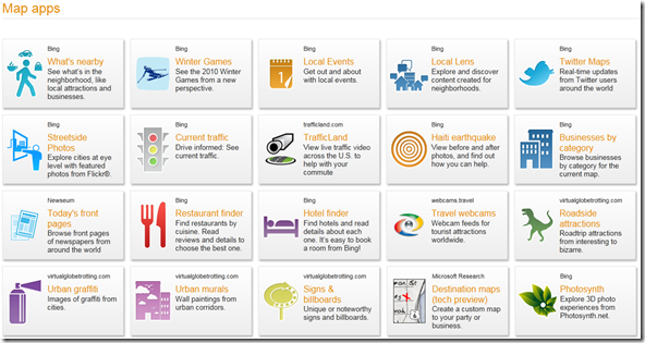
A great aspect of Bing Maps is the “Application Gallery” which currently has over 20 App’s and allows for 3rd party layers of data on top of maps.
Applications like one that uses the geoLocation data from tweets recently added in Twitter, displaying tweets on the map from the locations they were sent or Local Lens, which indexes blogs and tries to geolocate them to the map using clues from what is wrote in the post.
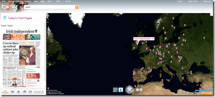
One of my favourites is “Today’s Front Pages” which shows the front page from major newspapers worldwide and this really gives us a new way to experience maps. Here we can see the front page of the Irish Independent.
Bing map’s integration of other services like Photosynth and Worldwide Telescope really gives it an edge over Google Maps. I can dive in and out of 3D photo experiences, look at Flickr pictures layered on top of Streetside images to see it, exactly how other people have seen it and if I get bored with the Earth, I can just look to the sky, all without feeling like I’ve left Bing maps.
All of this, plus what's coming down the road, is why Bing maps really is the better choice.
Please feel free to leave comments or to follow me on Twitter at @darrendoyle
SUH2MDHC32EK
Comments
- Anonymous
October 12, 2011
Great input. I love Bing Maps! It's so much more detailed and organized than Google Maps.

![clip_image001[5] clip_image001[5]](https://msdntnarchive.z22.web.core.windows.net/media/TNBlogsFS/BlogFileStorage/blogs_msdn/springboard/WindowsLiveWriter/BingvsGoogleTheShowdownoftheMapsAstudent_100A/clip_image001%5B5%5D_fdeb61f9-40be-417a-b70f-5ff4a2f967e5.png)
![clip_image001[7] clip_image001[7]](https://msdntnarchive.z22.web.core.windows.net/media/TNBlogsFS/BlogFileStorage/blogs_msdn/springboard/WindowsLiveWriter/BingvsGoogleTheShowdownoftheMapsAstudent_100A/clip_image001%5B7%5D_d34b9806-1f7b-415b-8761-3f89a4e060a3.png)
![clip_image002[5] clip_image002[5]](https://msdntnarchive.z22.web.core.windows.net/media/TNBlogsFS/BlogFileStorage/blogs_msdn/springboard/WindowsLiveWriter/BingvsGoogleTheShowdownoftheMapsAstudent_100A/clip_image002%5B5%5D_6f47c02a-3963-4ff0-97b4-76e438e8b36b.png)
![clip_image001[9] clip_image001[9]](https://msdntnarchive.z22.web.core.windows.net/media/TNBlogsFS/BlogFileStorage/blogs_msdn/springboard/WindowsLiveWriter/BingvsGoogleTheShowdownoftheMapsAstudent_100A/clip_image001%5B9%5D_fb59be3d-644b-4222-9ce7-0b4341198714.png)
![clip_image004[4] clip_image004[4]](https://msdntnarchive.z22.web.core.windows.net/media/TNBlogsFS/BlogFileStorage/blogs_msdn/springboard/WindowsLiveWriter/BingvsGoogleTheShowdownoftheMapsAstudent_100A/clip_image004%5B4%5D_c3886ce1-4901-4866-9040-227b85df80ba.png)
![clip_image005[4] clip_image005[4]](https://msdntnarchive.z22.web.core.windows.net/media/TNBlogsFS/BlogFileStorage/blogs_msdn/springboard/WindowsLiveWriter/BingvsGoogleTheShowdownoftheMapsAstudent_100A/clip_image005%5B4%5D_5ad4f67c-2b1c-40a9-ba14-cd192b90f84f.png)
![clip_image001[11] clip_image001[11]](https://msdntnarchive.z22.web.core.windows.net/media/TNBlogsFS/BlogFileStorage/blogs_msdn/springboard/WindowsLiveWriter/BingvsGoogleTheShowdownoftheMapsAstudent_100A/clip_image001%5B11%5D_bcc1095d-5eeb-4f4e-949e-f80e07555489.png)
![clip_image002[9] clip_image002[9]](https://msdntnarchive.z22.web.core.windows.net/media/TNBlogsFS/BlogFileStorage/blogs_msdn/springboard/WindowsLiveWriter/BingvsGoogleTheShowdownoftheMapsAstudent_100A/clip_image002%5B9%5D_1c31be41-3d92-4d4b-afa3-2f7eec1cffbc.png)
![clip_image008[4] clip_image008[4]](https://msdntnarchive.z22.web.core.windows.net/media/TNBlogsFS/BlogFileStorage/blogs_msdn/springboard/WindowsLiveWriter/BingvsGoogleTheShowdownoftheMapsAstudent_100A/clip_image008%5B4%5D_0d99de81-b44e-4da3-8618-532cbb0eec70.png)
