The GPS / Sat-Nav experience with the Touch-Pro 2 and CoPilot
One of the things with the change of phone means sorting out sat nav software. I’ve been using ALK’s co-pilot as my sat-Nav on the last two phones, with a Bluetooth GPS puck. I’ve been through 3 different versions of the software and I’ve grown used to its foibles. Since my phone arrived the day I was going to NEbytes in Newcastle I wanted to get CoPilot on installed right away and I decided to take the opportunity to upgrade to the latest version
 Sadly the ALK’s e-commerce site wouldn’t accept my old key to approve an upgrade and so I ended up paying full price – which was still a bargain £27. Then the site wouldn’t release the download – the download won’t work, even as a trial without the key, which only works on one device at a time, so the protection seems unnecessary. I’ve had problems getting to the point of installing CoPilot before and this time, as then their support line sorted everything out for me in a few minutes.
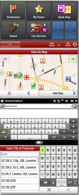
As it turned out – my phone hadn’t got past the initial handshake with the Network so I knew I wasn’t going to be able to activate CoPilot and I headed for Newcastle with the software on my laptop, but not yet on the phone. Installing the software is as simple as copying extracting a zip file to a memory card, Powering up the phone with card in it, and answering a couple of simple questions. Switching to a bigger touch screen changes the UI to something closer to a dedicated sat-nav unit, and its pretty self explanatory, touch friendly controls
Now , it wouldn’t be Copilot without some bit of User interface which doesn’t follow conventions – this time it’s the on-screen keyboard : Windows Mobile provides one and Copilot doesn’t use it. It provides an ABC layout instead of QWERTY. (See the bottom two images on the left for a comparison of the experience in CoPilot and elsewhere – in this case IE). I’m glad of the slide out keyboard! Aside from that it’s a pretty easy going. One of CoPilot’s strong points has always been up to date maps and Points of Interest which still seems to be true, there is a nice feature which tells you which motorway lane to get into in advance and the routing algorithm seems a little less inclined to go through town centres to save a small distance (although it still thinks it easier to get to the Microsoft office by driving through the centre of Reading) . All very easy to switch to, basically.
 It has a number of different modes including walking and cycling. I set it walking mode to guide me the last little way to Monday’s IT tweet-up in London. I was on the train at the time, doing 125MPH – hence the comical message “You are travelling faster than normal walking speed, would you like to change modes”. It was interesting watching the software trying to to match location to roads as we sped down the railway line – it’s worth remembering that the device saves a lot of battery time by throttling back the CPU so this can be expected to hammer the battery life. CoPilot has settings for managing the backlight – the other battery killer – “always on” is going to hit the battery pretty hard so is best kept for when the device is on external power, and leaving Windows Mobile to manage things actually suspends Copilot and turns the GPS receiver off until the device is switched back on. “Backlight: On Near turn” works pretty well, with one qualification; on the smartphone jabbing any button would bring the display back up, so on a long trip down the motorway one could see the software’s ETA or distance to the next turn. When the Touch-Pro 2 turns the display off it seems to turn the touch functions off so it is necessary to press the wake-up button not such a good thing when driving.
There are several advantages to ditching the GPS puck – not least the battery in it is at the end of its useful life so it has to be powered to be usable, and one integrated unit is always a better proposition. Reception is no worse as far as I can tell, and there are two implementation advantages. First Windows-mobile multiplexes the GPS between applications so it is possible to have co-existence between CoPilot, the various twitter clients I tried (see this post) which support GPS and a second GPS program – I also use Efficasoft’s GPS utilities when I don’t need navigational guidance - it’s great if what you want is a GPS compass, speedometer, or data logger. The second advantage is the GPS has a “pre-warmer”. When the receiver starts from cold it can get to a fix more quickly given an approximate position – the phone can get a rough position from the 3G network – the information available is not GPS-accurate (otherwise we could dispense with the satellites) but it speeds up the first plot dramatically – as I found emerging from the underground in London.
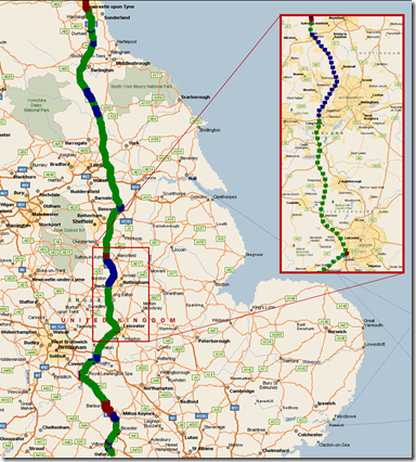
CoPilot automatically saves the logs from the GPS receiver which are in the started NMEA 0183 format, and it’s pretty easy to process these in anything which handles CSV files: Excel for example, or PowerShell. I thought it would be rather fun to plot speed against location so I did quick bit of data munging and pushed the information into MapPoint (MapPoint doesn’t seem to like importing Excel files with the 64 bit beta of office 2010 installed so I ended up using PowerShell, but any normal person would have used Excel). For each minute of data I averaged the speed, latitude and longitude and plotted the point a different colour – green for 55 MPH and up, blue for 40-55 MPH and Red for under 40. It’s pretty easy to spot the blocks of camera enforced speed limits through roadworks on my my return journey from Newcastle.
Depending how well the battery manages I may end up geotagging a lot more of my photos – that will be PowerShell again. The tip I learned for this from my diving is photograph the time on the data recorder (The Efficasoft tool in this case). The image of the time on the data is tagged with the time on the camera is of the time on the logger so you can workout the difference when tagging the pictures. I’ll come back to that another time.
Comments
- Anonymous
January 01, 2003
The comment has been removed - Anonymous
January 28, 2010
The comment has been removed