Fun with GeoRSS, Virtual Earth and WCF Syndication
WCF Syndication APIs are great. In just a couple of hours I wrote a simple GeoRSS feed, a fairly high level library to encapsulate the details of common entities (lines, points, polygons), all unit tests and a mashup with VE to test it.
I only encountered a couple of incompatibilities and problems (mainly related to XML namespaces) but everything was straight forward and easy. VE doesn't allow the RSS feed to come from a different server the map is hosted, so you need a proxy to walk around this limitation (Very well explained in this blog entry. A must read for anyone doing VE stuff. Thanks for the code!).
Being fairly new to this is space, I was amazed at the power off all these infrastructure components, and the apps that could be built with this stuff; and I know I have just barely scratched the surface.
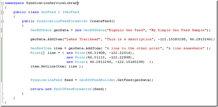
My library allows me to easily author a GeoRss feed:
GeoRssData is a simple object model for geo information. GeoRSSFeedBuilder translates the domain model into a RSS feed with the proper extensions. This is all quite easy with WCF Syndication classes. Finally this the result on IE:
Comments
Anonymous
December 24, 2007
PingBack from http://geeklectures.info/2007/12/24/fun-with-georss-virtual-earth-and-wcf-syndication/Anonymous
December 25, 2007
Did you run into this problem? http://forums.microsoft.com/MSDN/ShowPost.aspx?PostID=2293295&SiteID=1 Wondering if this was fixed the the Virtual Earth API, or if you found a way around the requirement for the geo namespace prefix?Anonymous
December 29, 2007
Yes, I ran into that problem. VE likes the extension elements fully qualified and I also wanted to leverage WCF Syndication. Here's what I did (the line element as an exanple) which was teh fastest and easiest way I found, there might be others though: private static SyndicationElementExtension GetLineExtension(Point[] line) { StringBuilder extensionXml = new StringBuilder("<georss:line xmlns:georss="http://www.georss.org/georss">"); foreach (Point x in line) { extensionXml.Append(x.Latitude.ToString() + " " + x.Longitude.ToString() + " "); } extensionXml.Append("</georss:line>"); XmlTextReader tr = new XmlTextReader(extensionXml.ToString(), XmlNodeType.Element, null); SyndicationElementExtension sext = new SyndicationElementExtension(tr); tr.Close(); return sext; }Anonymous
June 27, 2008
Some time ago , I did some experiments with Virtual Earth control and its features. I especially liked

