Outlining Postal Delivery Areas On Virtual Earth
 Melissa Data has just published a unique application that highlights postal delivery areas for any given postal code on a Microsoft Virtual Earth map. I was thinking WOW this would be an awesome data set of robust polygons and routes to see how hard our tax dollars are being used....but, apparently Newman and crew's delivery areas aren't that impressive at all. The application, however, is a great way to visualize this unique data set. You'll need to sign up, but that's free with some limitations on the number of queries and data sets you have access to.
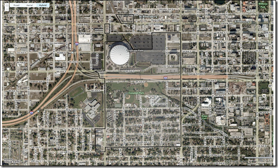
The data set, while robust and accurate in content actually highlights how small an area our federal workers actually have to cover. Maybe each postal delivery worker gets two or three areas. Using Virtual Earth to map the data on our road maps was interesting....
However, putting the postal delivery area on an aerial photo made it very clear just how many houses are in a given postal delivery area (not enough)....
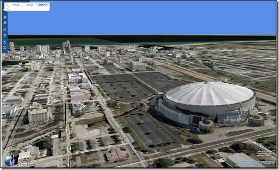
Putting the postal delivery area on our 3D map, well, that's just plain cool.....
It was hard to find the exact area I was looking for. I wanted the downtown block and there was no good way for me to find it short of clicking through all of the results to see which part of postal code 33705 was downtown. And, with a free account you only get 50 queries a day - I ran out quick and had to wait until today to finish this post. Feature request - when I click on the map, show me the boundaries for THAT area and the code numbers in a popup. You just need to use the PixelToLatLong() method in Virtual Earth to get the coordinates, send them to your spatial data source to find which polygon the point resides in, then return that respective polygon as a VEShape back to the map. Done.
In any case, the postal delivery areas data is probably used for sending out mailers to a specific neighborhood to target specific demographic groups and prospect for customers. I love when my mailbox is full of recyclables. Melissa Data actually has quite a bit of data included with their service all of which I'd love to see more and more end up on a Virtual Earth map.
CP
Comments
Anonymous
September 18, 2008
Personally, I'd be most interested in some direction in using Virtual Earth to outline postal code areas. This would be applicable to just so many situations.Anonymous
September 22, 2008
Thanks for noticing this Chris. Maponics crunches tens of millions of records each month to generate our ZIP Code and Carrier Route boundaries. We're very happy to be supplying the map data to Melissa Data. You can learn more at http://www.maponics.com/GIS_Map_Data/ZIP_Code_and_Carrier_Route_GIS/zip_code_and_carrier_route_gis.htmlAnonymous
October 08, 2008
Very useful post. thanks for sharing with me. regards http://www.sblgis.com/photogrammetry_services.aspx


